URBAN DESIGN STUDIO/ FALL - 95
NEW YORK CITY REGION
REGIONAL ANALYSIS

|
GLOBAL ECONOMIES:New York as a global city. New York serves as an important link in the 24hour, global trading system, which shifts between London, New York and Tokyo's time zones through the 24 hour cycle. The Downtown core played a crucial role in the historical formation of the national capital market, which have been eclipsed by the shift to Midtown, with the global emphasis of American international corporations and banks. The American Stock Exchanges, the World Trade Center and World Financial Center, along with a few bank headquarters, still remain downtown, but there is much office vacancy. Even Chase Manhattan will move its headquarters to Midtown with its merger with Chemical Bank.(Reference Saskia Sassen Global Cities /Castell The Informational City.) |
|
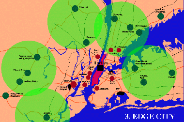
EDGE CITYAlong with the shift to the global economy, American cities experienced an enormous suburban expansion in the 50 years after the Second World War. Urban Geographers spoke of "Megalopolis", while Joel Garreau named the component parts "Edge Cities". Jonathan Barnett identified 5 clusters of growth along highway corridors around New York, which we used as the basis for our diagrams. Life in these corridors is based on the automobile and set in a semi-rural "green veil" of landscape (described by Stephen Kieran). |

|
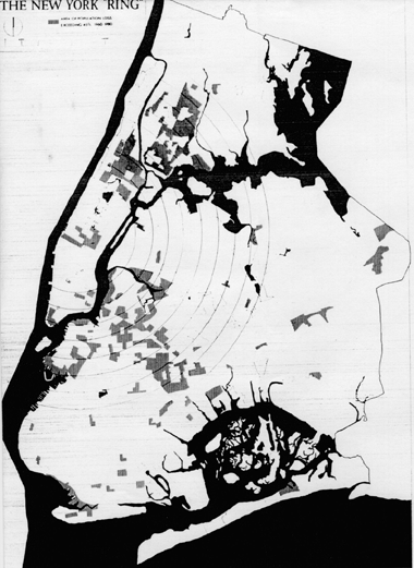
TRANSPORTATIONIn this drawing the ring road patterns of post 1945 highway construction (sponsoring the "Edge City") are contrasted with the old radial railway commuter patterns that served the inner city industrial areas and business cores. The regional airports are only accessible by automobile and highway, while the rail freight system concentrated on the port. The city subway system, which serves Downtown well, was also built before the construction of the airports. The Downtown core is by-passed by all the major highway systems. |
|
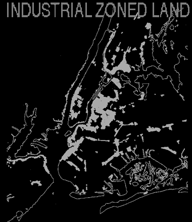
INDUSTRIAL ABANDONMENTThis image is based on a map prepared by the City of N.Y. Planning Department which shows the massive loss of jobs suffered by New York as industries moved to the suburbs, Sunbelt locations or repositioned their facilities to take advantage of the global labor economy after the Second World War. Urban Geographers have drawn similar maps for Los Angeles, coupled with the loss of hundreds of thousands of jobs. Robert Finch in the Assasination of New York argued that this job loss was in part due to a deliberate City policy of promoting Finance, Insurance and Real Estate Industries white collar jobs. The Harlem River Valley and South Bronx were two major industrial areas effected by this policy. The shift to trucking and the loss of barge-rail transfers in the port basin also effected these industrial areas. |
|
HOUSING ABANDONMENTThis image is based on the "Inner Ring" map in Richard Plunz's Housing In New York which showed where the collapse of the local housing market was severest, resulting in the abandonment of buildings by landlords and their foreclosure by the city. The loss of jobs and the collapse of the housing markets was especially marked in Harlem and the South Bronx. New York City became the largest landowner in both these areas in the 1980's. |
BACK[]DISTRICT[]PROBES[]HOME