|
|
|
Climate Change and Development in the Gambia
|
ClimateGambia lies within the tropical sub-humid eco-climatic zone with rainfall range between 800 and 1200 mm annually. The climate is characterized by two seasons, wet season (between June and October) and a dry season (November to April). The dry season is a 6-7 months of no rains. During the dry season, the climate is dominated by dry and dust-laden winds blow from the Sahara Desert in the northeast. These northeasterly winds are locally known as Hamattan. The early part of the dry season November through February is generally cooler with minimum temperatures of less than 20oF a common occurrence. Table 1. Temperature (degrees Celsius) Relative humidity (%), and rainfall at selected stations.
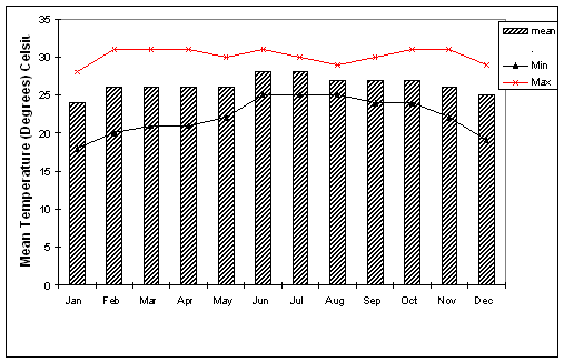
Temperature Average temperatures in the Gambia range from 18 to 28 degrees Celsius (65 to 82 degrees Fahrenheit) in January to 23 to 36 degrees Celsius (75 to 97 degrees Fahrenheit) in June. Higher temperatures are recorded as one travels east with mean maximum in summer months reaching 43 degrees Celsius around Basse Santo Su. Highest temperature ever recorded in the Gambia was 45oC (113oF) and the lowest temperature recorded was 9oC (48oF). Temperatures in Banjul and Kombo are moderated by Atlantic Ocean with less seasonal and daily variability in daytime temperatures. In an average year temperatures exceed 35oC (95oF) for only 34 days in Banjul compared to 112 days in Basse Santo Su. During the winter months, (December through March) temperatures fall below 18oC (65oF) for no more than 10 in Basse Santo Su compared to 56 days in Banjul and Kombo. Throughout the year temperature is high enough to permit plant growth although during the dry season, lack of water becomes an inhibiting factor.
Average mean, minimum and maximum monthly temperature in Banjul.
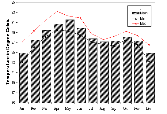
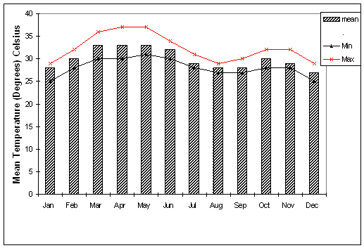
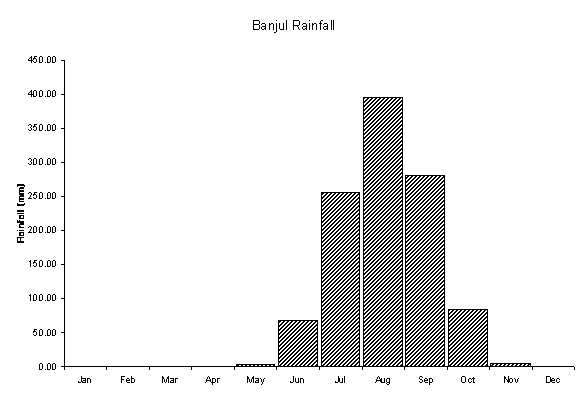
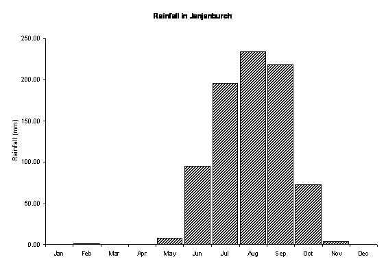
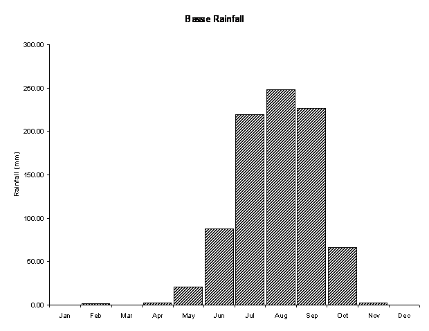
Figure 2. Mean, minimum and maximum monthly temperatures in Janjanbureh, 1960 to 1971. Figure 3. Mean temperatures at Basse Santo Su 1980 -1984 RainfallThe rainy season in the Gambia lasts 5 to 6 months with 98% of the rainfall occurring between June and October. August is the rainiest month in the ear with as much as 37% of the annual rainfall. The average annual rainfall has considerable spatial and temporal variation. Higher rainfall is received in the southwest part of the country with an estimated 1200 mm annually. The lowest annual rainfall is received in the north-northeast part of the country. Average number of rainy days range from 54 days in Banjul to 31 days in Basse Santo Su. Figure 7. Mean annual rainfall in Janjanbureh. NOAA Baseline Climatological Dataset - Monthly Weather Station Temperature and Precipitation Data. Provided by http://ingrid.ldgo.columbia.edu/SOURCES/.NOAA/.NCDC/.GCPS/.MONTHLY/.STATION/
Figure 7. Mean annual rainfall in Basse Santo Su. NOAA Baseline Climatological Dataset - Monthly Weather Station Temperature and Precipitation Data. Provided by http://ingrid.ldgo.columbia.edu/SOURCES/.NOAA/.NCDC/.GCPS/.MONTHLY/.STATION/ Rainfall in the Gambia, like the rest of the Sahel region is highly variable from year to year. Rainfall data in Banjul between 1951 and 1985 show both a high annual variability in total annual rainfall and a downward trend in mean annual rainfall over the 35-year period. Mean annual rainfall between 1950 and 1966 was 1347 mm, compared to 853mm during the period 1967 to 1985.
|
|
Home | Up | Greater
Banjul Area | Western Division | Lower
River Division | North Bank Division | Central
River | Upper River |