|
|
|
Climate Change and Development in the Gambia
|
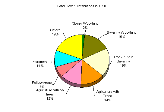
Land ResourcesThe total land area of the Gambia is 10466 sq km. The natural vegetation formations are classed into more woody Guinea woodland in the west and less woody Sudan savannah in the eastern part (Trolldalen 1986). Wetlands consisting of mangroves, barren flats and freshwater swamps make constitute 17% of total land area and the remaining 83% under various Sudanian-guinean savannah woodland formations. Over the last one hundred fifty years, the Gambia has experienced significant transformation of the natural land cover primarily deforestation. A number of anthropogenic and natural factors are blamed for the change in Gambian land cover. Top of the list is human population, either directly through consumption of land resources or indirectly through land use practices, vegetation fire management and grazing of livestock. Natural factors of include persistent droughts and saltwater intrusion up the river. The depletion of exploitable West African Mahogany timber was reported in a letter addressed to the British Secretary of State for the Colonies in 1832 (Rosevear 1937). Rosevear went to say that by 1910 trade in West African Mahogany have ceased as almost all the exploitable timber has been cut. In 1946, woodlands including mangroves covered an estimated 81% of the land area (FAO 1981). With no mineral resources, agriculture has been the Gambia’s main foreign currency earner. The strategy to increased agricultural production particularly groundnut in the 1960s and 1970s, through the introduction of animal traction have indirectly helped in the rapid clearance of the natural woodland cover (the prime source of fertile agricultural land). The introduction of the animal traction of the 1950s and 1960s had made it possible for farmers to cultivate larger areas. Woodland cover in the Gambia decreased to 57% in 1968 and by 1993 only 41% of the total land area was under some form of woodland cover type.
Adapted from Teusan (1999). The problem of human-induced land use change has been compounded by persistent droughts of the 1970s and 1980s, increased frequency wildfires, uncontrolled wood harvesting driven by raid population growth and urbanization. Land use change in the 1980s was primarily in the form of agricultural intensification. Deforestation in the 1980s is characterized by reduction of secondary woodland (previously cultivated fallow areas) as people adopt shorter fallow periods to maintain production. The urban population of the Gambia in 2000 is estimated at 566,000 or 41% from just over 22% in 1963. Rapid urbanization particularly in Kanifing Municipal Council and Western Division has resulted in the conversion of all but a few enclaves of natural land cover and agricultural lands. In addition to loss of agricultural productivity (physical removal of land from production), land cover transformation is directly linked to the local extinction of many flora and fauna of the Gambia. It is estimated that habitat loss due to woodland degradation and cropland expansion have led to local extinction of numerous species of mammals and many more are threatened with extinction. Forest ResourcesThe natural vegetation formations in the Gambia are dominated by woodland savannah freely drained soils and wetland (mangroves, grassland and mudflats) in the poorly drained seasonally inundated areas. The woodland formations are classed into woody Guinea woodland in the west and less woody Sudan savannah in the eastern part along a rainfall gradient (Trolldalen 1986). Until 1900s the Gambia was almost entirely covered by natural vegetation. As human population grew so was the need for settlement, cropland and grazing land, and leading to a gradual decrease in the natural cover. By 1946 an estimated 73% of the total land area in the Gambia was under woodland cover. By 1968 total area of closed woodland declined to about 26%. The first National Forest Inventory and mapping in the Gambia was carried out in 1980, and total woodland cover was 12% (Forster 1983). The second assessment, carried out by the Forestry Department in 1993 estimated woodland cover to be under 9%. Closed woodland declined from an estimated 60% in 1946 to a little over 1% in 1993. A number of anthropogenic and natural factors are blamed for the change in Gambian land cover. Top of the list is human population, either directly through consumption of land resources or indirectly through land use practices, vegetation fire management and grazing of livestock. Natural factors of include persistent droughts and saltwater intrusion up the river. Distribution of Forest Resources The composition of land use and land cover varies between local government areas. Western Division has the largest proportion of woodland (closed and savanna combined) area 36,000 ha (35.7%), followed by Central River Division, 25,200 ha (25%) and North Bank Division with smallest proportion of woodland with 9,600 ha (9.5%). Tree and shrub savanna, the largest natural vegetation cover type occupy about 100,400 ha (49.6%) in Upper River Division, 130,000 ha (43%) in Central River Division, compared to 34% of the national average and 12.5% in North Bank Division. Over 99,000 ha (30%) of all active agricultural land are in the North Bank, followed by Central River Division 79,000 ha (24%). Table 1. Land cover and land use distribution in each Division. Source: Ludwid and Bojang, 1998. Results and Analysis of the National Forest Resources Inventory1997/1998
|
|
Home | Up | Greater
Banjul Area | Western Division | Lower
River Division | North Bank Division | Central
River | Upper River |