|
|
|
Climate Change and Development in the Gambia
|
Landforms The geomorphology of the Gambia is dominated by the Gambia River. The River Gambia divides the country into two strips of land no wider than 30 km. The country is generally low-lying with nowhere in the Gambia above 60 meters. Over 48% of the total land area of the Gambia is below 20 meter high with nearly one-third of the country, at or below 10 meters above sea level. Only four percent of the country’s land area is above 50 meters.
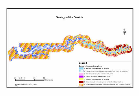
Figure.1 Elevation map of the Gambia. Source: United States National Aeronautics and Space Agency, NASA Shuttle Radar Topographic Mapping (SRTM) data. From the river outwards on can identify three topographic regions: (1.) The Valley bottom (2.) dissected plateau with sandy and (3.) a sandstone plateau. The Valley BottomThe valley bottom is the area immediately along the Gambia River and its tributaries. The area is characterized by poorly drained alluvial sediment formations. These areas are subjected to regular seasonal flooding. The combination of low-lying topography, poorly drained soils and abundant water provides unique and diverse habitats. The valley makes up nearly 4048 sq. km, 39% of the land area. From MacCarthy Island, westward, the valley broadens and seasonally inundated swamps or Faro in Mandinka, appear on either sides of the river. These swamps extend for more than 2km away from the river. The soils and vegetation in the valley bottom is primarily influenced by the hydrology. In western third of the Gambia, where the river water is salty or brackish, the soils are clay and alluvium and heavily impregnated with salt. The only vegetation that thrives in such condition is mangrove forest. Beyond the mangrove and brackish water are the Banto Faros (beyond the Swamps). The freshwater areas, the soils are often light alluvium and are more fertile and are for centuries the center for rice production in the Gambia. The natural vegetation in this area is dominated by swamps grass and marshes. Dissected plateau with sandy hillsUpland Gambia is dominated by dissected plateau with sand hills. This area is characterized by gentle rolling sand hills alternating with shallow valleys. In the coastal region, the soils are generally unconsolidated marine and aeoline sand with intermittent low-lying sand dunes. Underlying these unconsolidated soils are the ferruginous sandstones, which form cliffs about no more than 20 meters high of Cape St. Mary. In central and eastern Gambia the plateau is broken up by few flattop laterite sandy hills. Natural vegetation in the plateau is along a precipitation gradient, ranging from trees and shrub savannah in the northeast to multi-story tropical forest in the southwest. All but a few pockets of the original vegetation of the plateau areas are modified or converted for cropland expansion, settlement and wood collection. The plateau is the center for groundnut (the country’s number one cash crop) and coarse-grains (millet and sorghum) production. Sandstone PlateauThe eastern end of the country is enclosed by low, rocky sandstone hills, which extend into Senegal. Occupying about 4% of the total land area, these hills are often unproductive rugged, uncultivated, un-vegetated. The soils of this region are infertile but respond well to phosphate and nitrogen (Tralldalen 1991). Major crops in this area are groundnuts and millet. Geology and SoilsGeology of the Gambia is of relatively recent origin, Tertiary and Quaternary period. The country is part of the Tertiary Continental Terminal Plateau covering 53% of the land area with alluvial deposits of Quaternary period along the river (Geology and Mineral Resources of the Gambia 1988). Occasional marine intrusion and deposits on the terrestrial sand and sandstone characterize the geological periods. Alternation of wet and dry periods resulted in the formation of iron pan during the Pleistocene period.
Geological formations of the Gambia. Geology and mineral resources of the Gambia, 1988. Tertiary FormationsTertiary formations include complexes of the Oligocene, Miocene and Pliocene Epoch and are part of stable continental crust. The continental terminal series complex consisting of sand, sandstone, silt, clay and kaolinitic claystones represents this group. The age of the complex is estimated to be between 2.5 million years for the Oligocene to 33 million years for the Pliocene complexes. Quaternary formationsThe quaternary formations are very recent formations in the geologic time-scale less than 1.6 million yrs. The group consists of 6 formations in two epoch, the Holocene (completely recent) and Pleistocene (recent). Holocene complexes are estimated to be less than 8,000 yrs while the slightly older Pleistocene complexes are dated about 1.6 million yrs. Geologic complexes of the Holocene Epoch are primarily alluvial deposits of coarse sand and silt along the river and coastal beach complexes of undivided sand and silt. In eastern Gambia the quaternary formations away from the river are of ironstone, gravel formations.
|
|
Home | Up | Greater
Banjul Area | Western Division | Lower
River Division | North Bank Division | Central
River | Upper River |