|
|
|
Climate Change and Development in the Gambia
|
PopulationThe population of the Gambia in 2003 is 1,360,681 from 1,038,145 in 1993. This suggests an annual population growth rate of 2.9 % down from 4.2% during the 1983 to 1993 inter-census period. At this growth rate the population doubling time is estimated at about 25 years. Different Local Government Areas experienced different population growth rates as result of internal migration. After experiencing a 63% increase in population between 1963 and 1983, the City of Banjul experienced an annual decline in population of 4.2% between 1983 and 1993 and at an estimated rate of 2.2% during the 1993 –2003 inter-census period. This decline was due to an out migration from Banjul to the suburbs in Kanifing Municipal Council area as commuting to and from Banjul became easy. In 2003 about one-in-four Gambians live in the Greater Banjul Area, the region comprising the City of Banjul and Kanifing Municipal Council. The area occupies 93 sq. km (0.08% of the total land area). The proportion increases to 34% when we include Kombo North, the district bordering Greater Banjul Area. An estimated 747,400 live in the City of Banjul, Kanifing and Brikama Local Government Area, about 55% of the total population. Kanifing Municipal Council is the most densely populated district (4478 persons per sq. km), followed by the City of Banjul (1958 persons per sq. km) and Kombo North (459 person per sq. km). Districts with the lowest population density include Kiang West (19 persons per sq. km) in Lower River Division, Foni Bondali in Western Division (29 persons per sq. km) and Sami in Central River Division with a density of 32 persons per sq. km.
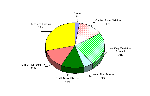
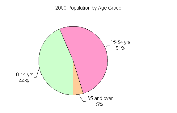
Figure 1. Proportion of country population in Local Government Areas in 2003. Source: National Population and Housing Census, 2003. Department of Central Statistics, The Gambia. The distribution of Gambia’s population has been greatly influenced by access to the City of Banjul and subsequently to education, employment and other modern living amenities. As the center for government, commerce, trade, education and relatively good healthcare services, access to Banjul was an important factor for population distribution in the Gambia. It was not until the establishment commuter services in the mid 1970s that population started sprawling beyond the confines of St. Mary’s Island in which the city is located. Since early 1980s, the population of Banjul declined from its peak of 44,200 in 1983 to about 34,828 in 2003. This primarily the result of people relocating to the Kombo St Mary area Bakau, Kanifing, Fajara and greater Serre Kunda now collectively called Kanifing Municipal Council, KMC. By mid-1990s over-crowding in KMC coupled with availability of modern amenities in Brikama and parts of Western Division immediately bordering Kanifing saw the explosion of their population. By 2003 the population of Western Division is estimated at 392,897 from 55,000 in 1963. The direct consequences of such an increase in population density include loss of land for cultivation, grazing and wildlife conservation. In other divisions, access to Banjul is an important determinant to population distribution. By 1960 all but a few towns with a population more than 3000 were located along the River Gambia, then the main transportation route. As alternative transportation became available through the construction of the Banjul-Basse Highway, the Barra-Farafenni road and the Trans-Gambia Highway new towns developed. By 1990, Division Headquarters like Kerewan and Janjanbureh saw their populations declined while new cities emerged at locations more accessible to Banjul namely Soma, Farafenni and Bansang. By mid- 1990s Farafenni became the commercial center in North Bank Division in place of both Kerewan and Kaur, and Soma became the de facto capital of Lower River Division due in part to their accessibility to Banjul. In Central River Division, Bansang replaced Janjanbureh as the provincial city. Over all 58% percent of the population in Central River Division and 72% of Upper River Division population live on the south bank along the Banjul-Basse highway. Demographic CharacteristicsLike many developing countries in sub-Saharan Africa, the Gambia’s population age-structure is heavily skewed to the youth. The population under 15 years in 2000 was estimated at 43.6% compared to 41.6% in 1973 (MICS 2000). The proportion of the population under 18 years old increased from 46.5% in 1993 to 50.4 in 1993. At the same time population aged 15-64 years declined from 52.5% in 1973 to 51.7% in 2000. The proportion of the population aged 65 years and above declined from 3.9% in 1971 to 3.2 in 1993 just to climb up to 4.6% in 2000. This increase in the over 65 years group is attributed to increase in life expectancy. Overall average life expectancy at birth had increased from 43 years in 1973 to about 55 years in 2000 (MICS 2000). The Gambia has one of the highest total fertility rates (TFR) in the world with Total Fertility Rate in 1993 at 6.04. Between 1963 and 1983s census years, national fertility rates remained relatively unchanged. The population and housing census in 1993 showed TFR in urban center of Banjul and Kanifing to be 4.7 compared to 7.25 in rural areas, a difference of nearly 3 children. Between 1983 and 1993, TFR in Banjul and Kanifing Municipal Council declined 15.5 and 15.4 percent respectively while Lower River Division experienced a 9.7% increase. Increase in Lower River could be attributed to rapid population growth in Soma. During the decade 1983 and 1993 Soma, the largest town in the Division experienced an annual growth rate of 14.2 percent. Similarly age-specific fertility rate for women in the 45- 49 age group is 41% lower in the urban areas than for their counterparts in the rural areas. Also among teenagers (15-19) urban births are 37% lower than rural births. These differences in fertility rates between urban and rural rates are attributed to differences in literacy, socioeconomic status and access to family planning facilities. Mortality rates in the Gambia are among the highest in the sub-region. Infant mortality in 1993 was estimated at 84 deaths per 1000 live births a significant decline from 167 deaths in 1983. Over the same period under-five mortality was estimated to have declined from 260 deaths per 1000 in 1983 to 129 deaths in 1993. Variability in mortality rates across Local Government Areas exhibit patterns similar to fertility. Low mortality rates are observed in Banjul and Kanifing Municipal Council (primarily urban) compared to the remaining Local Government Areas. Differences in access to primary healthcare, maternal educational attainment and overall differences in nutritional levels are attributed to temporal and spatial variability in overall mortality rates. For example, under-five mortality for children born to mothers with no education in 1993 was estimated at 138 deaths per 1000 live births compared to 120 among children of women with primary level education and 88 deaths per 1000 for children of women with secondary education and above. Figure 2. Estimates of age distribution in 2000. Source: World Development Indicators. World Bank 2004.
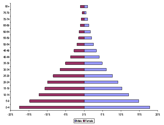
Figure 3. Age pyramid in 1993 Table 1. Infant mortality, under 5 mortality rate and life expectancy at birth in 2000
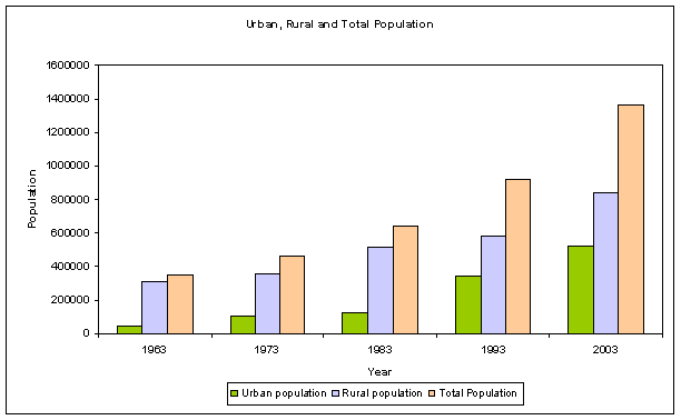
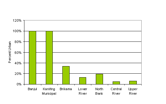
Source: Department of Central Statistics, The Gambia Urbanization The Gambia has one of the fastest growing urban populations in Africa. The proportion of the population living in urban areas in the Gambia increased from 22% in 1973 to 30.8% and 37.1% in 1983 and 1993 respectively. The proportion of urban population is 2003 is estimated at 41%. Since 1983 the urban population grew on average about 8% per annum over 2 time the national rate of growth. During the inter-census period 1983-1993, the town of Soma, the in Lower River Division registered 14.2% annual growth rate, the fastest rate of growth in urban centers throughout the country. Kanifing Municipal Council and Brikama Local Government Areas registered the fastest rate of growth, 8.2 and 8% respectively. Figure 4. Urban, Rural and Total population in the Gambia, 1963 to 2003. Source: Department of Central Statistics, The Gambia. Urbanization rate vary between LGAs with Banjul and KMC with the highest proportion of urban populations, 100% followed by Brikama LGA with 34% with Central River Division the least at 5%. Rapid increase in urban population has been one of the major problems faced by the Gambia. In addition to loss of arable land in the Kombos, the rapid increase in urban population has brought with it several environmental and socioeconomic problems including deforestation, soil erosion, pollution and waste generation, stress on health, education and employment services. Figure 5. Proportion of Local Government Area population that is urban Urban Change
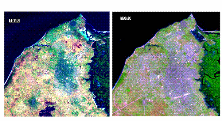
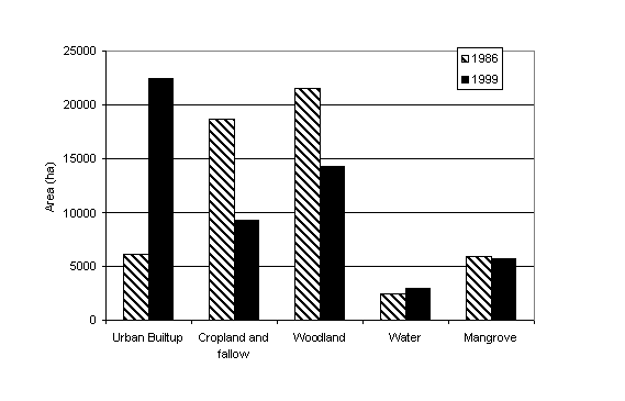
Urban extent in Kanifing Municipal Area and northern Kombo North District in 1986 and 1999 from Landsat TM imagery. Land use change characterized by expansion and intensification of urban builtup areas at the expense of croplands and tree cover.
| ||||||||||||||||||||||||||||||||||||||||||||||||||||||||||||||||||||||||||||||||
|
Home | Up | Greater
Banjul Area | Western Division | Lower
River Division | North Bank Division | Central
River | Upper River |