|
|
|
Climate Change and Development in the Gambia
|
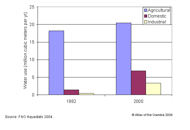
Water Resources Water resources in the Gambia fall under surface and groundwater. Surface water comprises of the Atlantic Ocean and the River Gambia and its tributaries. The Gambia has claim to 20530 sq km of exclusive economic zone in the Atlantic Ocean of which 5,725 sq km is continental shelf (Earth Trends 2003). The River Gambia and tributaries occupy 970 sq km permanent surface water area. During the height of the flood season, inland surface water including the River can extend over 1965 km2 about 18% of the total area. The Total Renewable Water Resources (TRWR) in the Gambia is estimated to be 8.0 km3/yr, of which 5.0km3 (62.5%) flows into the country from Senegal and Republic of Guinea (FAO 2003). Surface water produced internally is estimated at 3.0 km3 per year with annual internally renewable groundwater is estimated at 0.5km3. The Gambia’s annual water use is estimated at 30.6 million cu. meters about 0.38 percent of annual total renewable water resources. This is amounts to a per capita consumption of 23.5 m3 compared to 163 cubic meters in Senegal and over 1690 cubic meters in the United States of America (FAO/AQUASTATS 2003). About 67% of water withdrawal goes to agricultural use. Overall amount of water use has increase by 50% between 1982 and 2000 although per capita consumption has decreased from 29 cubic meters to 23.5 cubic meters a reflection of overall increase in population. Rapid increase in urban population and economic activity over the 20 yr period are two factors responsible for the increase.
Figure 1 Agricultural, domestic and industrial water use in the Gambia 1982 and 2000 The River Gambia The Gambia owes its name and existence to the Gambia River. European interest in the river as a major access and trading route into interior Africa led to the carving of the Gambia as an enclave in French West Africa. With its source in the Futa Jalon Highlands in Guinea, the river runs east to west for nearly 1000 miles through Republic of Guinea, Senegal and the Gambia. The total area of the River Gambia and its tributaries, locally called Bolon in Mandinka is 947 sq km. The river is only a couple of hundred meters wide at its narrowest point within the Gambia and nearly to 16 kilometers at the mouth near Cape Point. On entering the Gambia the River meanders for almost two-thirds of its 470 km course with large expanse of valley floodplains on both banks. Along the last 150 km towards the mouth, mangrove forests border the river. Ecological studies conducted in 1980s identified five ecological zones along the Gambia River, namely lower estuary, upper estuary, lower freshwater river, upper freshwater and headwaters (Moll and Dorr 1985). However, only three, the lower estuary, upper estuary and the lower freshwater river lie within Gambia’s borders. The lower estuary is the wide and relatively shallow part of the river from the Atlantic Ocean to 120 km upstream. This zone is primarily an extension of and heavily influenced by coastal marine waters of the Atlantic Ocean. In the lower estuary, the river is funnel-shaped with the river slow flowing, allowing tidal waves to mover into the lower reaches of the river (Moll and Dorr 1985. The River is up to 15 km wide and relatively shallow with the main channel some 3.5km wide and up to 12 meters deep running in the middle. On either side of the river are extensive tidal mud flats up to 2 km wide. The banks of the lower estuary are covered with mangrove forests extending up to 10 km from the river. The marine characteristics and large amount of mangrove detritus make the lower estuary valuable breeding and nursery ground for a large number of marine fish species. The upper estuary extends from 120km to 240km upstream. Although similar to the lower estuary both in terms of both containing brackish water and bordering mangrove forests, the upper estuary differ from the lower in many ways. Seasonal flooding influences water quality and thus the fauna and flora in this zone. The main channel of the river in this zone though only 500 m wide at Elephant Island is nearly 18 m deep. Extensive luxuriant mangrove forests extend up to 3 km away from the river along Bolons. Beyond the mangroves are seasonal floodplains. Annual floods produce significant changes in the physical and chemical conditions in this zone. During the rainy season floodwaters change the zone to freshwater the water and with it change in fish species from marine to freshwater species. The brackish waters also allow rice cultivation. During the dry season or drought years, saltwater influx from the Atlantic Ocean changes the zone into saltwater environment. Overall species diversity is lower in this zone than the lower estuary. The lower freshwater river extends from around Kuntaur, 240 km to the Gambia’s eastern border. The water in this zone freshwater all year around. Fish species diversity is much lower than the estuary zones with bottom-feeding catfish species the most dominant. The freshwater swamps or Banto Faros along this portion of the river are the main rice producing areas of the Gambia. Since early 1960s several irrigated rice development projects have been implemented in the area to increase self-sufficiency in rice, the staple food of the Gambia. The upper freshwater zone of River Gambia extends beyond the Gambia. Economic ImportanceThe Gambia River is one of the most important waterways in West Africa. The River Gambia is navigable to sizeable vessels to the countries eastern border. Ocean-going vessels up to 3000 gross weight can travel 241 km upstream to Kuntaur (Sagnia 1984). Earlier European presence in the Gambia River was primarily for commercial venture. The Portuguese were the first Europeans to settle in the Gambia round about 1450. The Portuguese established the first European trading post in what is now Tankular in about 1455 (Reeve 1912). Shortly after several trading posts were established in Bintang (Vintang by Portuguese), and Sika in Niumi. Trade in Ivory, gold, beewax was later replaced by human cargo as early as late fifteenth century (Archer 1967). Recent economic activities on the River are transportation, fishing and agricultural development. River transport is still the primary mode of transporting groundnuts (the nation’s) number one cash crop. Ferry services across the river including Banjul-Barra and Yelitenda-Bambatenda transport thousands of passengers daily throughout the country. Fisheries ResourcesThe Gambia is endowed with extensive fisheries resources. The Fisheries resources of the Gambia can be broadly divided into Marine and River Fisheries. The Marine Fisheries include the Deep water fisheries of the Atlantic Ocean within the country’s 200 nautical miles (374km) Exclusive Economic Zone (EEZ), the shallow continental shelf area and the Lower Estuary of the River Gambia. The most important marine fish species are pelagic species, including shad or bonga (Ethmalosa spp.) and sardinellas (Sardinella spp.) followed by demersal and semi-pelagic species, such as carangids (Carangidae); barracudas (Sphyreanidae); croakers and drums (Sciaenidae); porgies and seabreams (Sparidae); groupers and seabasses (Serranidae); threadfins and tasslefishes (Polynemidae); and grunts (Pomadasysidae). Marine fisheriesThe low-lying topography of the lower estuary allowing inflow of marine water from the Atlantic Ocean combined with extensive mangrove forest along either sides of the River providing large amount of detritus offer fertile breeding and nursery grounds for a large number of fish and crustaceans. The most important marine fish species are pelagic species, including shad or bonga (Ethmalosa spp.) and sardinellas (Sardinella spp.), but there are also appreciable stocks of both demersal and semi-pelagic species, such as carangids (Carangidae); barracudas (Sphyreanidae); croakers and drums (Sciaenidae); porgies and seabreams (Sparidae); groupers and seabasses (Serranidae); threadfins and tasslefishes (Polynemidae); and grunts (Pomadasysidae). A recent survey estimated total biomass of pelagic fish in marine fisheries to be 217,000 metric tons of which 54% and 25% were flat and round Sardinella spp. respectively, 18% were mainly carangids etc, and the rest (3%) horse mackerel. River fisheriesThe River Fisheries include freshwater areas in the Central River and Upper River Divisions and the brackish waters of the upper Estuary areas. Some of the most abundant species are tilapia (Oreochromis niloticus), African bonytongue (Heterotis niloticus), upsidedown catfish (Synodontis gambensis), catfish (Clarias lazera), bagrid catfish (Auchenoglanis occidentalis), Labeo senegalensis and Chrysichthus furcayus. The shrimp (Penaeus duorarum) and tonguesole (Cynoglossus senegalensis) caught along the river are purchased by industrial fishing companies for processing and export to Europe.
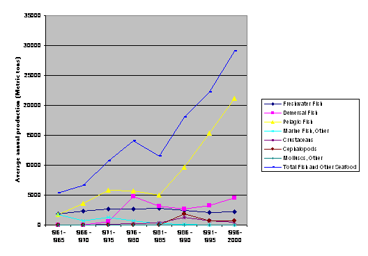
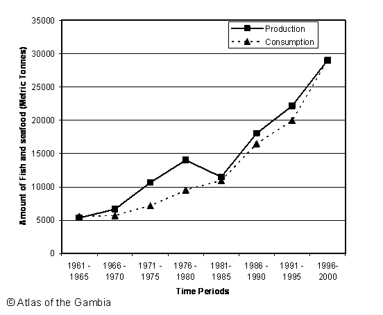
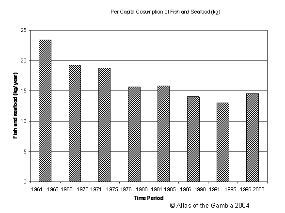
Figure 2. Production of different categories of fish and seafood in the Gambia between 1961 and 2000. Source. FAO AQUASTAT 2004. Production and Consumption of Fish and SeafoodFish is the primary source of animal protein for many Gambians with annual per capita consumption of 14.5 kg compared to 5.8 kg from other meat. Overall average annual production of fish and other seafood increased from 5380 metric tons during 1961- 1965 period to 29016 metric tons in 1996 – 2000 period. This increase was mainly driven by development of the Marine Pelagic fisheries. Output from freshwater fisheries has remained relatively small with a small decline after 1981 perhaps as a result of droughts and increased salinity of streams and swamps along upper estuary areas of the river. Increase in fish catch did not however result in increase in per capita fish intake, which dropped, from 23.4kg in 1961-65 to 145 kg in 1996 - 2000. Accessibility to fresh fish continued to constrain capita consumption particularly in rural interior as much of the increase output is centered along the coast.
Figure 3. Amount of fisheries and seafood production and consumption in metric tons Figure 4. Per capita consumption of Fish and seafood in the Gambia between 1960 and 2000.
|
|
Home | Up | Greater
Banjul Area | Western Division | Lower
River Division | North Bank Division | Central
River | Upper River |