|
The
Northwest Frontier with Afghanistan |
|
|
|
*MAP*
|
Extends through Sections 1
and 3 |
 |
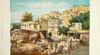
Tourist posters show the
picturesque, romantic
Northwest as it's supposed to be |
 |
Some perspectives on what
Robert D. Kaplan calls "the
ungovernable
border"; a closer look at *the
tribal
territories* |
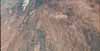 |
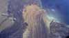
A sobering view, from space,
of *Kabul*
and its environs-- at the western end of the *Khyber
Pass* |
 |
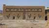
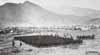
PESHAWAR, at the eastern end
of
the Khyber
Pass |
 |
The mountains run down
southward
into BALOCHISTAN... |
 |
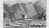
QUETTA,
and
the Bolan Pass--always fought over, always bad terrain
for fighting |
 |
And the mountains terminate
in the
harsh
MAKRAN desert to the south
|
|
|
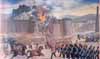 |
The First Afghan War
(1839-42),
despite
some local victories, ended in a massacre and deep
public humiliation
for
the British; *a
British soldier's perspective* |
 |
In the intervals between
punitive raids, the
British tried the effects of formal darbars |
 |
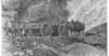
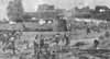
British and Indian troops in
Afghanistan,
1878-80, during the Second Afghan War |
 |
The "Black Mountain
Expedition,"
1888, and other ventures in what is now Pakistan's
North-West Frontier
Province
|
 |
The "Indian Frontier Rising,"
1897; some views of the troops and their lives
|
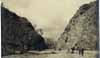 |
The Ahani Tangi Pass in
Waziristan
was the
scene of a ferocious battle in 1920 |
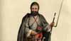 |
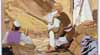
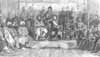
Views of Afghans, Baloch, and
other tribesmen, and their lives
|
|
|