Frank da Cruz
5 June 2003, updated from time to time
Most recent update: Mon Jul 14 08:57:46 2014
URL: http://www.columbia.edu/~fdc/running/
Featured in the New York City section of Worldwiderunning.com.
Runners who live in the Columbia University area of Manhattan, New York City (Morningside Heights and West Harlem) are fortunate to have Riverside Park, Central Park, and Morningside Park nearby. The parks and the Hudson riverfront are in better condition now than at any time in the last 100 years, especially since 2000 with the inauguration of the Greenway, and the 1980s when we stopped dumping raw sewage into the Hudson. This page describes some obvious and not-so-obvious runs that start in the Columbia area, but it should also be useful for anybody who lives on the west side anywhere between midtown and Washington Heights / Inwood.
Thanks to Aleida Morel, Walter Bourne, Victor L. Schuster, and Deborah Wassertzug for contributions.
I moved to the North Bronx* in 2012, so I won't be updating this page much any more. If you click on the link in the preceding sentence you'll see a runner's paradise: green (and Greenways) in all directions: Van Cortland Park, Mosholu Parkway, Bronx Park, Oval Park, the Jerome Park Reservoir, Pelham Parkway, Pelham Bay Park, and the Bronx River Greenway under construction... I might start a new page but with Google Maps it would be almost superfluous, especially when you use it with "apps" like this and this to map out and measure running routes on satellite photos as well as street maps. Meanwhile, I had a note from Bob Rosen in February 2013 by way of update:
“...if you miss your upper Manhattan runs, there's a pedestrian path across the Henry Hudson Bridge that connects just south of the toll plaza to a newly renovated path into Inwood Park and then over the tracks to Dyckman Fields. They're building a new ramp from Dyckman St to the greenway, bypassing the current Staff St. route and also developing the path along the river between Dyckman and the Little Red Lighthouse. I've lived all over the city but have been in "upstate Manhattan" the last 24 years. It's my favorite nabe for running, by far. Just wish I still had the young legs I did back then!” (Don't we all!)_______________________
| * | Bronx geography can be a little confusing. The Northwest Bronx can also be considered the East Bronx because the boundary between East and West is Jerome Avenue (which is like an extension of Fifth Avenue into the Bronx). |
Disclaimers:
Rules of Thumb for Manhattan Running:
Most of Manhattan is laid out on a regular grid of crosstown numbered streets and north-south numbered avenues, which make it easy to figure distances:
Maps and Tables (verified May 2012):
If you like running in little circles, there's an outdoor asphalt track nearby, about 1/10 mile, same as the CU track, in the little park between International House and the Interchurch Center at 122nd Street and Riverside Drive (at least there was once, I'm not sure if it's still there). There's also a cinder running track at 74th Street by the River, also about 1/10 mile, but with air, trees, and a RVR VU.
Central Park Drive Schedule: It's silly for me to put the schedule here because it changes all the time. Here is the the Central Park Dot Com web page where the schedule is published:
http://www.centralpark.com/pages/general-info/park-drive-regulations.htmlIf that link doesn't work, search Google for central park drive hours. When the Drive is open to traffic, the inner lane is reserved for runners, walkers, bikers, and skaters, but you have to take the 72nd Street transverse instead of going all the way to the bottom of the park, which cuts the distance by a mile. The Central Park West entrances at 110th and 106th Streets have been closed to traffic since 1992.
I don't recommend running in Central Park off the Park Drive or Reservoir path for a variety of reasons: footing is trickier, various obstacles, crowds, etc, and some paths can take you to secluded places that might not be safe (e.g. the 102nd Street transverse, the Rambles, etc). Running in the dark by yourself is probably not a great idea either, although I've done it (there were long stretches with absolutely no light, I literally couldn't see a thing). I've run there in every kind of weather, including once when it was 5°F and blanketed with falling snow — there was not a sound and I had the whole park to myself; it was like running on a cloud.
Some people like to run around the perimeter sidewalk but I don't recommend that either — the footing is dangerous, especially on Central Park West, and it's often crowded. The distance is the same as the Park Drive tour: 6.2 miles. You can also run around the bridle (horse) path, but running on loose dirt can be a chore — or a better workout depending on your point view. In any case the bridle path consists of three distinct loops between a mile and 1.5 miles each, which can be combined in various ways.
Btw, you can also run to and from Central Park along 110th Street if you want. Above 107th Street, Broadway is equivalent to 11th Avenue, and Central Park West is 8th Avenue, so it's half a mile from Broadway to Central Park. But I usually walk; it's a good way to warm up and cool down.
Did you know...? Riverside Park, in its present form, was constructed in its entirety by the New Deal in the 1930s through public agencies like CWA, PWA, and WPA. Including the malls that cover the railroad tracks, the retaining walls, the paved walkways, the playgrounds, the 79th Street Boat Basin, you name it. Wikipedia doesn't seem to know about this, but let's give credit where it's due. NEW (July 2015): New Deal Tour of Riverside Park.(MAP) Middle Riverside Park extends from 96th to 120th Street, so a round trip is 2.4 miles (in fact it continues north to the 125th Street highway off-ramp, but there is not much of a path, and at the northern extreme you'll find yourself on the West Side Highway off-ramp). You can run inside the park or along the sidewalk overlooking the park. The sidewalk route includes a big hill from 96th Street to 103rd Street, and another from 115th to 120th, whereas inside the park is perfectly flat if you stay on the main level, and has some gentle hills if you take the "high road" along the stone retaining wall. Park entrances are at 120th, 116th, 115th, 108th, 103rd, 98th, and 97th Street (116th and 97th have ramps with no stairs). There's a "secret path" through the woods between 116th and 120th Streets; see if you can find it (careful, tricky footing).
The centerpiece of the middle park is the Mall, 101st to 110th Street, tree-lined, almost exactly half a mile long and perfectly straight and flat, paralleling the operational Amtrak train tunnels, somewhat reminiscent of the Jardin des Tuileries but without the statuary, another good place for beginners. The middle park also has a lower tier, where the baseball fields are (and some volleyball courts, basketball courts, a miniature soccer field, etc), and a path you can take that runs along the highway behind the athletic fields (to reach it, take the stairs down just north of the Mall at 112th Street).
Throughout Riverside Park, you'll find footpaths created by generations of runners. Some people prefer them but you must be constantly alert for puddles, rocks, holes, exposed tree roots, protruding metal pipes, etc. Staying on the smooth pavement lets you ignore all that and enjoy the scenery.
As of Spring 2004, many of these footpaths have been blocked off and reseeded. Meanwhile, many of the asphalt-covered paths have been improved and are now good for running, such as the one from 110th to 116th Street along the retaining wall overlooking the skateboard playground, which used to be crumbling and full of potholes.
Did you know there were bats in Manhattan? If you run along the Lower Riverside Mall at nightfall, you can see them darting about just above your head (eat those bugs!). Normally you would extend a Middle Riverside Park run into the lower park. If you stay in the lower park (i.e. don't cross under the highway to the river) you end up at 72nd Street, where the park ends. From Columbia to 72nd Street and back through the Park is a nice 4-mile run (or slightly more, depending on where you start) with hardly any hills.
If you exit from the Mall down the path that branches off towards the River at 86th Street, then under the highway, you can run along the river past the 79th Street Boat Basin, down to the new Donald Trump pier at 70th Street and, if you wish, you can keep going as far south as you want¹. First past the twisted rusty mangled burnt-out (i.e. picturesque) wreckage of the old West Side piers in the 60s, to the Sanitation piers in the upper 50s, then along the working piers in the mid-50s and 40s, where you'll see big cruise ships docked and the Intrepid at 42nd Street, then past the Javits Center in the 30s, and so on, all the way to Battery Park. Once you reach the 50s, it's pretty surreal running in midtown Manhattan. (I've gone as far as 34th Street and back; presumably one could take the train down to Battery Park and run all the way back for the full effect...) The only bathrooms I know of on this route are just south of the Boat Basin, about 74th Street, and (May 2006) some Port-A-Potties at about 55th Street.
As of late May 2010, the box below is historical. Now there is a fully realized paved, fenced, and landscaped path along the river from 59th Street all the way up to 145th Street, as the final section of the Greenway between 86th and 92nd has been completed. And the stretch from 72nd to 59th is much improved with landscaping, benches, boat ramps, free kayaking, tables, piers, sunbathing seats, a café, and new walking paths in addition to the running/biking/skating paths; it's very well done, as might be expected for this part of the Manhattan, at the foot of Trump City or whatever it's called... (I'm not complaining about the part north of 145th Street; it's passable, picturesque, more rustic, and definitely more fun!)
I should mention that there are two ways get between middle and lower Riverside Park, which are divided by the 96th Street West Side Highway ramp². The recommended and safe way is on the Riverside Drive sidewalk, where there is a traffic light and an official crossing. The fun way is down along the river; go under the highway at 100th Street, then run south along the river-edge promenade alongside the tennis courts. When you reach 92nd street, the promenade ends at a fence. Climb over the rocks that are piled up to keep you out and proceed south along the edge of the highway (May 2006 update: no more rock pile, now you have to go around the fence). The path gets a bit narrow and scary in spots, close to the speeding cars, but eventually you come out at the Boat Basin and can proceed southwards by the path described in the previous paragraph. (Or, if you value your life, you can go back under the highway at 92nd Street and up to the lower Mall and then back down to the River again at 86th Street.) The NYS DOT and NYC Parks Dept committed to adding a "cantilevered section" to the Greenway between 92nd and 81st Street "by 2003" but all they did was put up a fence and barriers to keep people out. In August 2004, the relevant NYC Department of City Planning website said, "The waterfront path will be expanded when the bulkhead is repaired and a cantilevered structure is added. The path will then be a 14-foot wide separated-use greenway. DPR needs more funding for this project, but it is expected to be complete by 2018."
I suppose I should not leave out the route along the Riverside Drive sidewalk
south from 96th street. Although it's hilly with a poor running surface,
you'll see some very handsome row houses, not to mention the Joan of Arc
statue at 94th Street (across Riverside Drive, easy to miss), the Soldiers and
Sailors Memorial with big cannons at 89th Street, and the statue of
Eleanor Roosevelt (no cannons) at 72nd Street.
________
Anyway, at the 135th Street end of the viaduct, you can turn around and come back, or if you want to do another 1.4 miles, go up to 139th Street and enter Riverbank State Park (i.e. the top of the North River sewage treatment plant) (AERIAL PHOTO). If you've never been to Riverbank State Park, you'll be surprised; it's the only state park in Manhattan, complete with pool, ball fields, skating rink, basketball and handball courts, a concert stage, a carousel, picnic areas, even park rangers:
Or you can run past Riverbank State Park and keep going north on Riverside Drive.
There's another viaduct, equally spectacular, between 152nd and 155th Streets (River and NJ on the west, Audubon Terrace and Trinity Cemetary on the east), then a looooong hill up to 163rd from which you can coast down to 165th, where you can:
July 2004 update: I found a way to get from Riverside Drive to the new path along the Highway. As you approach the GWB on the west side of Riverside Drive, after crossing a couple highway exits, you come to the place where the Drive and the Highway merge. Rather than leap into highway traffic, you can follow the asphalt path that curves around to the left. It's blocked off with a big log, perhaps for good reason, but you can jump over the log and follow the path down and around and through a dense wood. The asphalt soon disappears but the path continues around and brings you back to the street level under the Bridge, where you can see it blocked off with a cement barricade. From here you can see the new path, about which more just below. For safety, you should not take this path alone, because it is completely hidden from the road and everywhere else.
Eventually you can find the once old decrepit overgrown but now gloriously renovated sidewalk along the west edge of the highway where you can run all the way up past the Cloisters to Dyckman Street, just shy of the tolls. For decades, this path was narrow, overgrown, and crumbling but now it's wide and clean with a perfect-for-running asphalt surface. I've done this a few times, and saw all sorts of wildlife in the adjoining woods — raccoons, possums, skunks, etc. The sidewalk ends at Dyckman Street, where you can:
I checked the route up Riverside Drive from 112th to 162nd on July 8th 2006, it was fine, open and clear all the way, no contruction. It's a terrific five-mile run with spectacular views and, in the summer, the delicious aromas of family cookouts from 135th Street northwards.
The Cherry Walk surface is perfectly smooth asphalt with excellent drainage. There are never any puddles. My only quibble is the way the bicycle and running lanes are laid out; the bike lane is relatively flat, whereas the runners lane is slightly banked for drainage, which can be hard on the knees and ankles. Originally it was the other way and they changed it.
The lanes don't work anyway. The narrow west lane is clearly marked PEDESTRIANS ONLY (including runners). The wider east lane is clearly marked for bicyclists and skaters IN BOTH DIRECTIONS. But "everybody knows" you're supposed to keep right, so northbound runners in their own lane are met by a constant onslaught of oncoming bikers, many of whom play chicken with you because they believe they are in the correct lane and we runners are wrong. On the other hand, if we run north on the right, the few southbound bikers who actually read and obey the signs yell at you for breaking the rules. This has become increasingly annoying to me, but I can't find out who in city government to talk to about it. To check that I wasn't overreacting, on Saturday, 25 September 2004, I kept count on a 6:00pm run from the south to the north end of Cherry Walk:
Southbound bikes in pedestrian lane: 35 Southbound bikes in bike lane: 0
As you exit Cherry Walk at 129th Street (St. Clair Place) you see the brand-new (Fall 2008) Greenway extension where the 125th Street fishing pier (PHOTO) and the Fairway parking lot used to be. It was opened to the public in late October 2008, so now you have an unobstructed path northwards. It might not be obvious, but you have to go to the right; the path is on the far side of the fence, on the other side from where the guardhouse is.
Also see:
In the 1980s, before there was a Greenway and 12th Avenue was still the meat packing district, the viaduct was closed for renovation for about a year and you had to run along 12th Avenue to go north. I remember trying to hold my breath for 10 blocks — it's not easy but breathing was worse! Next to the elevated West Side Highway is an elevated railroad bed. Trains used to stop here and unload cattle for slaughter. Now the area is mostly demolished in anticipation of the construction of the new Columbia West Harlem ("Manhattanville") campus. Some trendy restaurants have opened up on the periphery but mainly it's a big open pit.
Previously the route from here north was the well-hidden Meridian Street. Now Meridian Street is blocked off and bypassed by another new landscaped Greenway section that goes from 135th to 145th Street, snaking around the construction and storage sheds through terrain that used to be overgrown with kudzu. That the shacks are still there lends a small touch of authenticity. At 145th Street the new path swings left and joins the upper Riverside Park path (if you go straight you'll see what the path you just took used to look like).
This is a major development because the stretch from 129th to 145th Street was (along with a stretch from 92nd to 96th Street) one of the last missing links the Greenway on the West Side. Now you can run along the river all way from Battery Park (the sourthern tip of Manhattan) just about to the northern tip of Manhattan (as of late May 2012 the official map is still not updated).
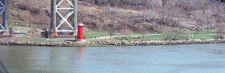
From here you can run along the River through the upper 140s and the 150s, where there are big community cookouts on summer weekends with delicious smells and blasting merengue, salsa, and bachata that give you a jolt of energy. Riverside Park turns into Fort Washington Park at 155th Street, but you won't notice. Reportedly falcons live there. When you come to what seems to be the end of the path at about 165th Street at some baseball fields, turn right (east, away from the river) and the path continues around behind the fields, like a shady country lane along the railroad bed, and then comes out within sight of the Little Red Light House at the base of the bridge, which is one of the all-time great destinations. Before coming here, be sure to read the book. As of July 2009 (and checked again in May 2012) the bathrooms just south of the bridge are open.
Here's a little gallery of the area from May 2012, photos by Amy (click on any image to see a larger version):


The George Washington Bridge is awesome — that's the only word that fits. You can't appreciate how HUGE it is until you approach its base on foot and look up and across from underneath. (Later I'll tell you how to get on it and run to New Jersey.)
The rest of this section is mostly historical. The real way to continue north from under the GW Bridge is to follow the paved path up the steep hill, across the railroad bridge, until you come to the West Side (excuse me, Henry Hudson) Highway (er, Parkway), where since about 2004 there is a completely renovated bicycle and running path along the west edge of the highway that goes all the way to Dykman Street (or to be precise, Staff Street, which takes you to Dykman), with foot bridges across the highway every so often. The ascent from under the bridge to the highway is probably about 200 feet, you'd have to be a pretty serious runner to take it running.
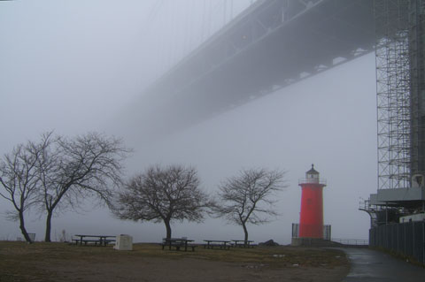
|
| "Little Red Lighthouse in more tranquil times", Photo by Jeff Bogumil |
You can also leave the trailroad tracks after a few hundred meters through another hole in the fence and take the path to Dyckman Street. It's quite rustic and "unimproved" — I saw an osprey nesting there once long ago (like an eagle, that swoops down on the water and grabs fish with its talons). Eventually I came out into what seemed like waist-high dune grass and then there was a shingle house right on the water with lawn furniture and some boats; I thought I was in Nantucket! A bit farther on was a little gate that let out onto Dyckman Street. Anyway now there's a new (early 1990s) marina at the end of Dyckman Street, and the path from the bridge to Dyckman street is marked on the map as "Planned Greenway (to be constructed)" — until then it remains a trail blazed by adventurers.
July 2004: My daughter Amy and I took the train to Dyckman Street, walked over to the River, tried without success to find where to get on the newly renovated running path along the highway, so went through the little gate instead and headed south. The new marina extends for some distance in this direction, and the shingle house is now a big metal shed housing the Inwood Boat and Canoe Club; it seems the original structure burned down in 1989 (you can read a history of the Dyckman Marina HERE). Anyway, the path is still rustic and unimproved, most of it through waist-high grass and thick vegetation. As it approaches the GW Bridge, there is a stretch where the river squeezes right up against the railroad bed, and you have to go through a hole in the fence and run for several hundred meters along the train tracks on big loose rocks — no fun! Then you can scoot up a short but steep hill and join the paved walkway that goes down to the base of the Bridge (or up to the West Side Highway). More about this path, officially known as the Amtrak Corridor, HERE.I found out later that the way to get on the new highway path from Dyckman street is to go up Staff Street, which angles up sharply from Dyckman just before the marina, on the left as you face the River.
So, in summary, for the trip between (say) 110th and Dyckman Streets, there is a High Road (Riverside Drive and the West Side Highway) and a Low Road (along the River), so you can go one way and come back the other. Crossing points are at Dyckman itself, the GWB, Riverbank State Park, and elsewhere if you are creative. The round trip is about 10 miles.
By the way, if you're on Dyckman Street at the River, you can enter the large
flat river-edge park north of Dyckman, the part of Inwood Hill Park that's
west of the highway, that has several baseball fields and some great
views, and hardly anybody who doesn't live in that area knows about it. It
extends to the northernmost tip of Manhattan at Spuyten Duyvil, and you can
run the length of it (about 2/3 mile) along the water.
________
The bridge's upper roadway has pedestrian walkways on both sides (north and south). The south walkway has the Manhattan skyline view; the north one lets you access the Palisades. Finding the walkways can be a bit tricky, and often one or both of them is closed, so take your chances (as far as I know, there's no way to find out in advance). The north walkway is visible from 179th and Fort Washington, but includes an unexpected detour down some interesting steps into the interior of the bridge structure and back up (only after that can you find out whether the walkway is open). For the south walkway, you have to go west on 179th Street to Mother Cabrini Boulevard, turn left, and then you can see a long winding pedestrian/bike ramp at 177th Street — a veritable ribbon in the sky — up to the south footpath.
The bridge is 0.9 mile between anchorages but at least a mile counting access ramps, and it's hard to imagine a more exhilarating run. Be prepared for stiff winds though, and don't do this if heights bother you (the railings are plenty high, nobody ever fell over them by accident). When you get to the New Jersey end you can turn around and come back, or you can try your luck on the Palisades. I did this once — it only works if you took the north footpath (the south one leaves you in Fort Lee on the wrong side of an uncrossable superhighway). When you reach land, make your way north and east towards the cliffs that overlook the river (you might have to navigate some dangerous intersections). There's a path that follows the edge of the cliff, through the woods, as far as you want to go, miles and miles. Spectacular views (CLICK HERE to see one), but tricky footing — pay attention (May 12, 2012, a piece of the Palisades, including the trail at the top, tumbled into the Hudson [CBS News]; this happened approximately across the river from Yonkers).
Also see:
Of course there other ways to cross to the Bronx. If I were to do this again, I'd take the newly constructed pedestrian crossing from the west side of the Highway to Dyckman Street, then enter Inwood Hill Park from there, cross it to Baker Field, and from there to the Broadway bridge. There are also lots of bridges to the Bronx on the east side (Willis Avenue, 138th Street, 145th Street, 155th Street, University Heights, High Bridge, Macombs Dam Bridge, Washington Bridge, ...) but I haven't tried them yet and I think some of them might be closed. There's also a footbridge to Ward's/Randall's Island; I haven't tried that either. (I recently made a trip to Highbridge Park on the Harlem River north of 157th Street but it doesn't appear to be runnable — most of it is either playgrounds or else heavily wooded wilderness on steep slopes, but it's big and there might be parts I missed. There used to be a big amusement park here.)
In response to the above, I am told that Highbridge Park definitely is runnable, although the northern portion is hilly. A Sierra Club trail map shows the trails; (CLICK HERE for more about Highbridge Park). Furthermore, the 2-mile Harlem River Speedway has been reopened after some 80 years of neglect; it runs along the Harlem River from East 163rd Street to Dyckman Street.
Update, July 2009: The Speedway is very nice. You can enter it at the East end of Dyckman Street, where it touches 10th Avenue. The Harlem River Drive and the (very narrow) Harlem River itself, and the Bronx, are on your left as you go south, and Highbridge Park on the right [MAP]. The flat part goes for about 3000 feet, then there's a hill which is blocked by a barrier, which you can step around. The hill goes to the Washington Bridge at 181st Street, I'm not sure what happens after because at that point I went up through the park to Laurel Hill Terrace. From the satellite photo it's not clear if the path continues southward from there, even though the park itself goes all the way to 155th Street.There is also a path on the other side of the highway, along the riverbank. It appears to be accessible from a footbridge on 10th Avenue about 40 meters north of the intersection with Dyckman Street. According to the Manhattan Greenway Map, the Greenway path extends to 155th Street, but it's not clear if this refers to the path on on the park side of the highway, or the river side.
P.S. As of September 2012, I live in the Bronx and run all over the place to the extent that I still can.... Mosholu Parkway, Van Cortlandt Park, Bronx Park, Pelham Parkway, Jerome Park Reservoir, Southern Boulevard...
In May 2005 Amy moved to Bay Ridge, Brooklyn, near Bay Ridge and 3rd Avenues. The prospects for running are much better there. Go west a few blocks on Bay Ridge Ave and you come to the beginning of a 5-mile long Greenway paved bike and running path that runs along the water (the part of New York Bay that separates Brooklyn from Staten Island) toward Coney Island (see Brooklyn / Staten Island bike map). The views are great, especially after you pass the Verazzano Narrows Bridge heading south, where the whole Atlantic Ocean seems to open up before you. At this writing there are distance markers painted on the surface every quarter mile (distance from Bay Ridge Ave). Some areas have sinkholes or cracks, but these are well marked and there's always a detour on the adjoining bike path.
In Staten Island there are fully realized Greenway paths along the shore at various points, but the last time I was there (Sep 2001) they were not connected and apparently still are not (see map). The one along the north shore, going east from the Saint George Ferry terminal, has a spectacular view of New York Harbor, lower Manhattan, and the New Jersey ports, but it's less than a mile long.
Obviously there are a great many more places to run in New York City than I've discussed here — Flushing Meadow Park, Van Cortland Park, Bronx Park, Prospect Park, etc — but so far I haven't tried them.
Flash: I just happened upon the official list of all NYC parks bathrooms... It's here. Apparently there are I many that I never dreamed existed, even in places where I go all the time.
Name Number Lexington Avenue 3½ (between 3rd and 4th Avenues) Park Avenue 4th Avenue Madison Avenue 4½ (between 4th and 5th Avenues) Avenue of the Americas 6th (South of Central Park) Lenox Avenue 6th (North of Central Park, old name) Malcolm X Boulevard 6th (North of Central Park, new name) Adam Clayton Powell Jr. Boulevard 7th (North of Central Park) Central Park West 8th Avenue (from 59th to 110th Street) Frederick Douglass Boulevard 8th Avenue (North of 110th Street) Manhattan Avenue 8½ (North of 100th Street) Columbus Avenue 9th Avenue (59th to 110th Street) Morningside Drive 9th Avenue (110th to 121st Street, then curves west) Amsterdam Avenue 10th Avenue (North of 59th Street) West End Avenue 11th Avenue (59th to 107th Street) Broadway 11th Avenue (North of 107th Street) Broadway Approximately 4th Avenue (South of 14th Street) Riverside Drive Approximately 12th Avenue (North of 72nd Street)
Broadway is a pre-grid street dating from pre-Dutch times, when it was the Wickquasgeck Road, part of a much longer Algonquian trade route; the Dutch renamed it Brede Weg, the English translation is Broadway. It runs diagonally south of 107th Street. Riverside Drive is curvy, not straight like other avenues; there are spots in the 120s and 130s where Riverside Drive and 12th Avenue coexist. For all practical purposes, 9th Avenue stops at 121st Street where, as Morningside Drive, it curves west to join Amsterdam (10th) Avenue. There is no exact equivalant of 9th Avenue in Harlem (Convent and parts of Saint Nicholas are close), but then it makes a VERY brief reappearance up around 204th Street. In fact Harlem and Washington Heights are home to all sorts of avenues that defy the grid: Edgecombe, Hamilton, Convent, Cabrini, Haven, Fort Washington, Macombs Place, St Nicholas south of 124th Street and north of 149th Street, etc; then the whole pattern breaks down completely above 190th Street (just as it does below 14th Street). You can't measure precise distances by counting blocks up here (or down there).
By the way, some crosstown streets have names when they should have numbers, but at least in recent years the City Parents have had the good sense to also show the number on the sign, usually (Saint Claire Place is 129th Street, Martin Luther King Jr Blvd = 125th Street, Seminary Row = 122nd Street, Reinhold Niebuhr Place = 120th Street; Cathedral Parkway = 110th Street, Duke Ellington Boulevard = 106th Street, etc).
You should also be aware that
125th Street goes off on a northward tangent
west of Saint Nicholas Avenue: by the time it reaches the Hudson River it is
north of 129th street. So when you are told (for example) that Cherry
Walk goes from 100th to 125th Street, which is true, don't use this fact to
figure its length because it also goes to 129th Street on the grid. This, by
the way, is why LaSalle Street has a name and not a number — it would be
125th Street on the grid, but 125th is already there, two blocks to the North.
Similarly, Tiemann Place should be 127th but it would be way too confusing to
encounter 122nd, 123rd, LaSalle, 127th, and then 125th — and then
130th! —
while strolling north on Broadway. Btw, did you know there are two
134th Streets near the river? See if you can find them.
Route Miles Km Remarks Columbia Gym Track 0.1 0.16 10 times around = 1 mile. Morningside Drive Circuit 1.2 1.9 One end to the other and back. Morningside Park Perimeter 1.6 2.5 Around the outside of the park. Central Park Reservoir 1.6 2.5 A circular track. Riverside 96th to 116th Circuit 2 3.2 116th to 96th and back inside the park. Riverside 96th to 121st Circuit (1) 2.5 4.0 Down to 96th, up to 121st, back to start. Riverside 116th to 146th Circuit (2) 3 4.8 On Riverside Drive sidewalk, park side. Central Park Reservoir twice 3.2 5.1 Twice around. Riverside 112th to 72nd Circuit (3) 4 6.4 Down to 72nd and back. Riverside 96th to 136th Circuit (1) 4 6.4 Up to 136th, down to 96th, back to start. Riverside 115th to 155th Circuit (2) 4 6.4 Up to 155th and back. Riverside 14th to 114th 5 8 Take the train to 14th, walk to River, run back. Riverside 115th to 165th Circuit (2) 5 8 Up to 165th and back (big hill at 155th). Cherry Walk Circuit 5 8 As described above Dyckman Street to 112th 5 8 Take train to Dyckman Street, run back. Riverside 96th to 146th Circuit (1) 5 8 Up to 146th, down to 96th, back to start. Riverside 96th to 146th Circuit (1) 5.5 8.9 Ditto but with Riverbank Park tour. Cherry Walk North End to 72nd Circuit 5.7 9.1 Along the river the whole way. Christopher Street to 120th One Way 6 9.6 Start at Christopher Street pier (4). Riverside 116th to 57th Circuit 6 9.6 Down to the big salt pile and back (5). Central Park Drive Full Circuit 6.2 10 As described above. 115th to Little Red Lighthouse Circuit 6.5 10.5 As described above. Riverside 112th to 42nd Circuit 7 11.3 112th to the Intrepid and back (5). Riverside 114th to 34th Circuit 8 12.9 To Javits Center and back (5). Battery Park to 116th One Way 8 12.9 Take the train to South Ferry, run back (5). 116th Street to Fort Lee Circuit 9 14.5 As described above. 96th to Little Red Lighthouse Tour 10 16.0 Cherry Walk Circuit extended to Lighthouse 112th to Dyckman Street Tour 10 16.0 High Road and/or Low Road 114th to 14th Street Circuit 10 16.0 Down to 14th along river and back (5). 116th Street to Spuyten Duyvil Circuit 12 19.3 As described above. Central Park Drive twice 12.4 20 Described above. 116th Street to Orchard Beach One Way 15 24.1 Described above. 116th to Battery Park Circuit 16 25.7 To Battery Park & back along Greenway (5). 116th Street to City Island One Way 17 27.4 Described above. Central Park Drive three times 18.6 30 Described above.
OK, that's it for starters. The real tour is the New York City Marathon which I did once and recommend it highly — it's an experience you won't forget. Nowadays it's almost impossible to get into it, but it doesn't hurt to try (the Marathon is in November, the lottery drawing is in April, so you should start planning a year in advance). The first NYC Marathon was in Central Park in 1970: 127 runners, four times around the Drive plus another 1.4 miles. The current 5-borough tour began in 1976 and nowadays there are well over 100,000 applicants for 45,000 spots.
[ Top ]