 |
COLONIAL MAPS from c.1750 to c.1900 |
|
HISTORICAL ATLAS* (DSAL, highly ZOOMABLE) |
=*Mughal
disintegration and the rise of regional powers,
c.1707-1766** =*the expansion of British power, 1766-1819** =*the expansion of British power, 1819-1857** =*colonial administrative divisions, 1857** =*the revolt of 1857-59** =*territorial and administrative changes, 1857-1904** =*regional population densities, 1872-1901** =*cities of over 50,000 population, 1871-1901** |
|
|
=*Library of Congress world maps**, with many from this period |
|
|
=*Historical maps, c.1750 to 1800*, by Charles Joppen (1907): *Carnatic wars*; *1751*; *Hyder, 1780*; *Mysore 1784*; *1795* |
|
|
=*Calcutta city maps, 1756 and onward* |
|
|
=*the
Battle
of Plassey, 1757*, Clive's crucial victory-- and
an English account of Bengal, 1757 |
|
|
=*North
Coromandel
(1757); Bengal (1760); both coasts (1763); India
(1781), etc.*, by Thomas Kitchin; very detailed
and helpful |
|
|
=*India
in 1760, as Clive found it*: several views
including Rennell's (1764) |
|
|
=*Asia, with political borders*, a huge and useful overview map by Jean Janvier, Paris |
|
|
=*India, Asia, and various other maps, 1760s to 1790s* |
|
|
=*India,
Asia, 1770s on*, by Rigobert Bonne: esp. the huge =*South and Southeast Asia, 1771* |
| BENGAL, 1775 |
=*Carte du Bengale, 1775*,
by W. Bolts |
| RENNELL'S NORTHERN INDIA, 1776- | *"Bengal to Bihar"
and "Delhi to Allahabad"*, spectacular huge maps by
the father of modern Indian cartography |
|
|
=*Many regional maps of the Middle East and Asia, c.1780*, by Louis Brion de la Tour |
| GANGES and GHAGRA, 1784 |
=*The
Ganges and the Ghaghra*, an early map based on a
Persian original, by Anquetil du Perron, 1784 |
|
|
=*Colonial maps from the Cambridge Modern History Atlas, 1912** (P-C) |
|
|
=*India and the world, 1772-1892*, by S. R. Gardiner (1892): *1785*; *1804*; *1857* |
|
|
*Overview map of India 1700-1792*, from the *Historical Atlas by William R. Shepherd (1923)** (P-C) |
|
|
=*good political maps, esp. for the South, 1794 on*, by Robert Wilkinson |
|
|
=*historical maps, c.1800 to 1856*, by Charles Joppen (1907): *1805*; *1823*; *1848*; *1856*; *Bengal* |
|
|
=*India, Asia, by Aaron Arrowsmith, 1800 on*-- the work of the Royal Hydrographer was widely circulated |
|
|
=*India, Asia, and various other maps, 1800 to 1850* |
|
|
=*India and the world, 1814*, from Ostell's Atlas, London |
|
|
=*Hindoostan, 1824*, by Anthony Finley |
|
|
=*Hindostan, 1826*, by W. and D. Lizars |
|
|
=*"Asia," from Atlas Universel (1827)**, by Philippe Vandermaelen |
|
|
=*SDUK
maps, c.1830's and 1883*, two magnificent sets,
the latter astonishingly detailed |
|
|
=*India, Asia, 1840*, by John Archer |
|
|
=*Asia, 1844* by Jesse Olney, Hartford, CT |
|
|
=*North India and beyond, 1850* by J. W. Lowry |
|
|
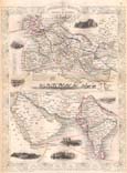
=*Regional maps, and the new overland (and Arabian Sea) routes, 1851*, extremely famous decorative maps by Tallis and Rapkin |
|
|
=*India, Asia, and various other maps, 1850 to 1900* |
|
|
=*Lucknow
just
before the Rebellion* |
|
|
=*Delhi
just before the Rebellion* |
|
|
=*a British view of Delhi just before the Rebellion* (unique) |
|
|
=*Company
administrative divisions, 1857** =*maps and views of the military situation during the Rebellion* =*the revolt of 1857-59** |
| INDIA, 1860 |
=*post-1857 political
map by W. G. Blackie, 1860* |
|
|
=*"Weekly Dispatch" maps, c.1860's*, excellent regional maps by Edward Weller; including his huge maps of *Asia* and *India* |
|
|
=*"India," 1861*, a beauty by SDUK |
|
|
=*"South Asia" and "Asia," 1873*, by John Bartholomew |
| HISTORICAL ATLAS OF ASIA |
=*"A
Literary and Historical Atlas of Asia"**, by John
G. Bartholomew, ed. Ernest Rhys, London, 1860-1920 |
|
|
=*"Kashidarpana," 1876**; a pilgrimage map |
|
|
=*Maps by A. K. Johnston*, especially *India 1878* |
|
|
=*an extremely detailed (Urdu) historical map of Shahjahanabad*, by Bashir ud-Din Ahmad (1919) |
| CENTRAL and SOUTH ASIA, 1881 | =*Central and South Asia, 1881*, by Richard Andree |
| LETTS' INDIA SET, 1883 | =*India
maps from Letts' Atlas, 1883*, superbly detailed |
|
|
=*Asia and India, 1885 on*, by George F. Cram |
|
|
=*"A Historical Map of British India Since 1751"*, by I. S. Clare, 1891; and his map of ancient *"Caucasian nations"* |
|
|
=*CONSTABLE'S 1893 AREA MAPS OF INDIA*, available thanks to *rootsweb** with the very helpful *index of place names** |
|
|
=*Iran to North and South India, 1897*, Century Atlas |