London and Croydon Railway
Norwood
In which Joe describes further how atmospheric railways worked, and visits four more locations where there is nothing left to see except a blue plaque at one of them, and ends up talking about dinosaurs.
Explorations: Tuesday, 20 June 2017, and Tuesday, 9 October 2018, and
Tuesday, 18 June 2019
Journey: New Cross Gate to Norwood Junction,
London Overground
-
OFTEN CITED REFERENCES
- Howard Clayton, The Atmospheric Railways, the author, 1966.
- Charles Hadfield, Atmospheric Railways, David and Charles, 1967.
- John T. Howard Turner, The London, Brighton & South Coast Railway , volume 1, "Origins & Formation", B.T. Batsford, 1977.
- John T. Howard Turner, The London, Brighton & South Coast Railway , volume 2, "Establishment & Growth", B.T. Batsford, 1978.
Jacob Samuda and his younger brother Joseph D'Aguilar Samuda had it easy with the atmospheric railway in Ireland. One train went back and forth on a single track, and the piston carriage stayed at the upper end of the train, the train length being changed by pushing cars on and off the lower end, so absolutely no switching was required. Passengers changed cars at Kingstown. There were no intermediate stations, so no need to stop the train midway. The Dalkey engine house pulled the train up, and since it returned by gravity, the piston was simply lifted clear of the pipe, with its front end left in position facing up the hill.
The Croydon railway posed all of those obstacles that the Dalkey railway did not. So far I have mentioned the mystery of how they changed between locomotive and piston carriage at Forest Hill while the passengers stayed aboard, and the task of rotating the piston to point forward but not the rest of the assembly under the piston carriage. The new challenge for the section between the Forest Hill and Norwood engine houses was that there were two station stops in between.
Another challenge for the promoters was the death of Jacob Samuda on 12 November 1844, when an engine he designed exploded on the ship Gypsy Moth, killing him and six others. Charles Hadfield wrote, "His was the best brain and the finest mechanical engineering ability behind the atmospheric systems, and if he had lived, it is just conceivable that the story might have ended differently." His brother Joseph had to go it alone, with able assistance from London and Croydon engineer William Cubitt.
At its opening in 1839 the London and Croydon Railway had four intermediate stations between Forest Hill and Croydon: Sydenham, Penge, Anerley, and Jolly Sailor. The railway was two tracks throughout, and the four stations were simple affairs with a platform on each side and a station house on one side. Penge was so lightly used that it was closed in 1841, so it was not an atmospheric station. Jolly Sailor was renamed Norwood on 3 July 1845, before the atmospheric began running.
Stage 1 of atmospheric operation, Forest Hill to Croydon, was opened to the public on 19 January 1846. It had separate pipes north and south of the central Norwood engine house, so that trains running south were pulled by Norwood and Croydon, and those running north by Norwood and Forest Hill.
This is what the piston carriage looked like:
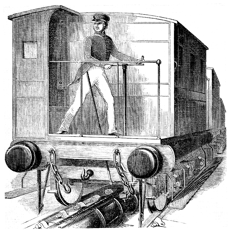
— source unknown, via Hadfield.
I have found three versions of this picture. The one above must be the earliest, Hadfield preferred it, using it inside and also in a color version for the book jacket. Howard Clayton describes "a very smart uniform of white trousers, swallow-tail coat, and peaked cap" that matches the image above. I wonder whether white trousers were chosen to emphasize that there was no soot from a locomotive.
Clayton gives also a careful description of the piston carriage that matches what we see above. First of all it had three axles. The middle one had larger wheels and was attached to the "perch", from which descended the arm to the piston. The axles of the other two pairs were below the level of the perch and were carried on springs, which may have given a rocking motion as the train moved, although it also cushioned any difference between the momentum of the heavy train and the push of the piston.
To the driver's right is a mercury tube connected to the head of the piston that showed the amount of vacuum measured in inches. A speedometer invented by Moses Ricardo was also installed at first, and it was the basis for the reporters' stories about the speeds reached. The driver had two controls, as seen in the picture. His hands are on a brake wheel. The slanted lever to his right operated a valve in the piston that allowed air to pass through, and this together with the brake was used to stop the train at intermediate stations. The pipe is shown with the hinges on the left side of the linear valve.
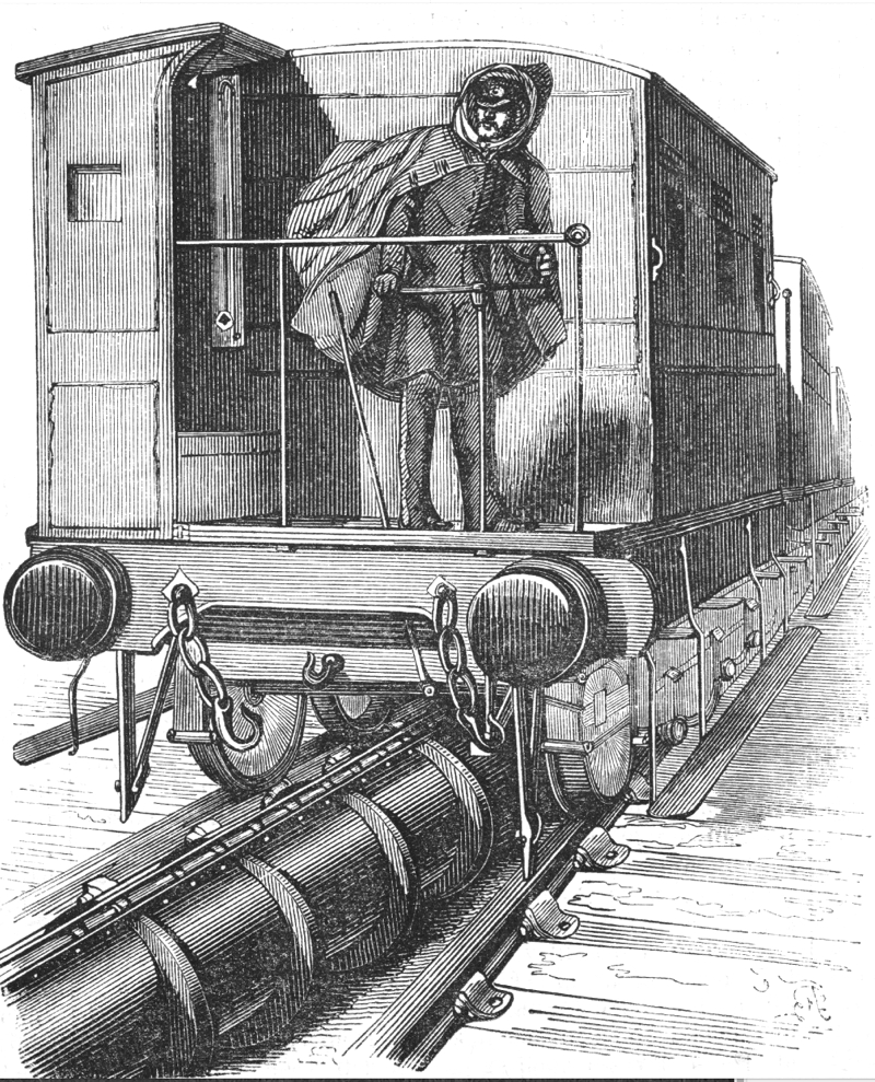
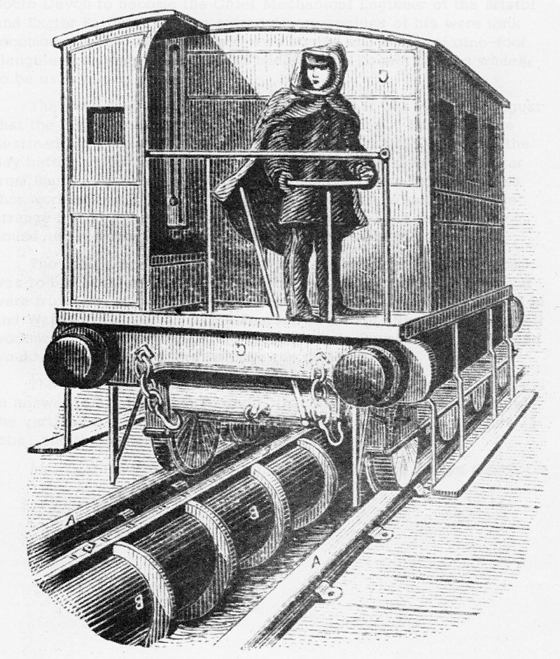
Compared to the picture above, the two variants are mirrored left-right, which is sometimes an artifact of artists preparing woodcuts. I have mirrored them again to match their exemplar. Neither artist understood the hinges on the linear valve, and the second mistakenly drew four wheels per side. The first was found on the web from a source unknown, and the second is much later, from A History of the Growth of the Steam-Engine by Robert Thurston, (New York: Appleton, 1878). You might notice that the drawing of a train on my previous page for Forest Hill shows the enclosed corner to be on the driver's right.
The beginning of atmospheric operation was not smooth. A few weeks before opening day a crankshaft broke in the Forest Hill engine house. On opening day, 19 January 1846, one of the two crankshafts broke at the Croydon engine house, and later in the day the other one did too, requiring locomotives to fill in for two days. Samuda blamed the manufacturer for using cast iron instead of the less brittle wrought iron as specified. Clayton, who goes into great technical detail about the engines, makes a good point about the failures.
The makers overlooked the effect of a phenomenon which affected all the atmospheric railways— the collection of water in the traction pipe. This was the result partly of condensation of the moisture in the air drawn out of the pipe, and partly rain-water which had entered the system. Water, unlike air, cannot be compressed, and so, when it was drawn into the pump, it should have had a rapid means of escape if damage to the machinery was to be avoided. On the Dalkey engine two large outlet valves allowed this to be done, but the London and Croydon engines had a large number of small, spring-loaded outlet valves, so that water in the pump could not escape quickly. Consequently, as the piston neared the end of its stroke, any water present in the pump cylinder caused a shock such as might have been effected by any sudden obstruction (for example, a bar thrust between the spokes of the flywheel), thus throwing a tremendous strain on the moving parts.
Breakdowns continued for about a month. Hadfield records: 1 February, lack of vacuum, and a piston damaged by "points" (Cubitt's apparatus, or normal points?). 2 February, lack of vacuum. 3 February, piston carriage and passenger cars derailed at points. 4 February, piston carriage derailed at Croydon. 5 February, piston carriage derailed at Forest Hill, and locomotive working because of lack of vacuum. Hadfield also notes that "the engine foundations were not strong enough to take the weight, and had to be strengthened with brickworks and bearing girders." In April a beam broke in one of the Forest Hill engines and "shifted part of the engine-house wall", but other than that it seemed by that time that the worst was past.
Let's look at the stations.
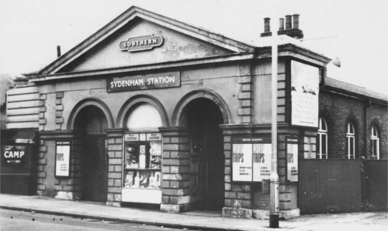
SYDENHAM
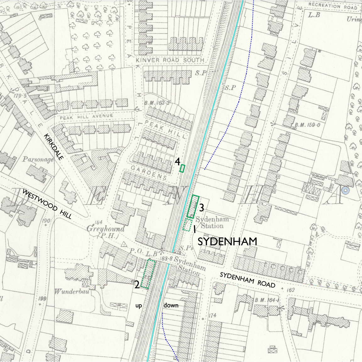
— Sydenham station, Ordnance Survey 25-inch, 1897. CC BY-NC-SA 4.0 courtesy National Library of Scotland.
Annotations by Joseph Brennan: atmospheric track (light blue line), possible site of the 1839 station (1), site of 1854 station up side (2), circa 1875 station on the down side (3), up side entrance of 1982 (4), and approximate center line of canal (dashed dark blue line).
As you can see, many changes have been made at Sydenham. Most of my information is from John Howard Turner's volume 2, where he cites plans filed by the London Brighton and South Coast Railway in 1852 for the widening to four tracks.
At the bridge under Sydenham Road and for a short distance north, the two tracks of 1839 were sited at approximately the location of the center tracks today, with a station on the down side (1 on the map). I say "approximately" because work was done to fit the atmospheric track along the original down platform, which might have been done by narrowing platforms, but Howard Turner found evidence of the up platform being shifted back as well. Still, by 1852 the post-atmospheric third track for locomotive trains was stopping at down platform 1 at just about the same location as the end of the down platform today.
As part of the rebuilding for four tracks, the LB&SCR wanted to straighten the railway between Sydenham and Penge, and replace the 1839 Sydenham premises with a larger station on the south side of the bridge. Property north of the bridge need not be acquired if the fourth track was built over the site of the old up platform. That was done, and the new up side station and platform at 2 were built along the straight track. The down side however was not relocated, because of a new development. The company decided to build a branch line to reach the Crystal Palace, which was being erected on a large property made available by one of the company directors. To get the most favorable grade up a rise of about 100 feet, the engineers proposed to start the southbound track just beyond the bridge, using the land vacated by the straightened alignment to gain altitude and then swing west over the main line. As a result the southbound branch track runs more or less in the line of the atmospheric track and the locomotive third track that had replaced it.
The existing down side station 3 seems to date from about 1875, implying that the 1839 station had survived that long. The Heritage Audit of the London Overground calls 3 "one of the best preserved historic structures on the New Cross to Croydon line and a positive contribution to the Sydenham Thorpes Conservation Area. It should therefore be retained." I agree.
The last change was the abandonment of the up side 2 because the retaining wall along the cut was in danger of collapse. The new up side 4 of 1982 has what the Heritage Audit calls "spartan mean facilities for passengers awaiting London-bound services" and recommends rebuilding it with something better. The work included a footbridge between the platforms, but passengers who cannot take stairs need to walk a roundabout route from Sydenham Road to reach the step-free access from a little residential street called Peak Hill Gardens. The platform extends north beyond Kinver Road South (and that's why I let map extend that far).
Below is a postcard view of the 1854 up side station 2. It has been misidentified as dating from 1839, but in addition to the unlikely large size and Italianate architectural style, an obvious objection is that the south side of the road is the wrong place.
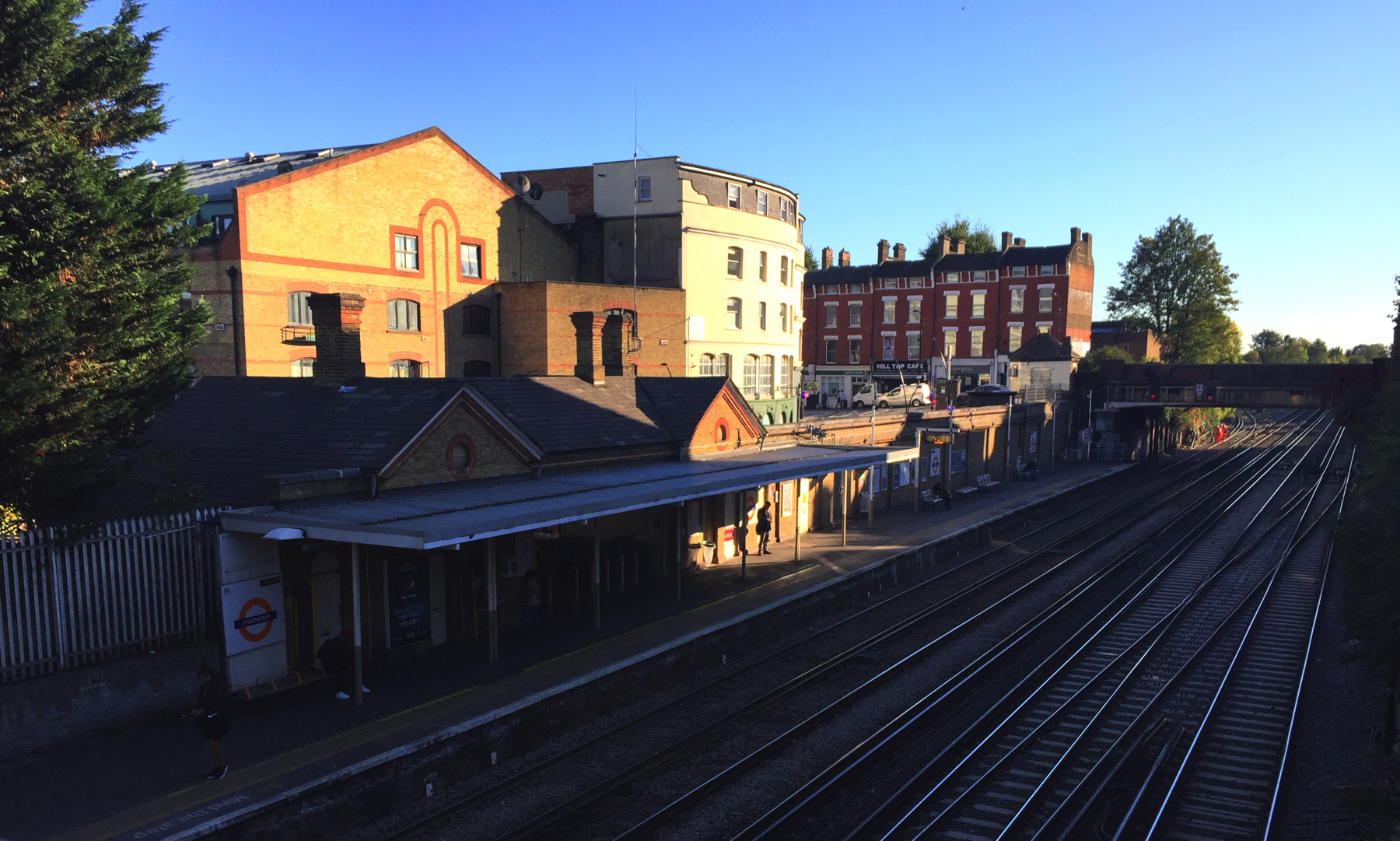
Above, a view from the footbridge as the sun goes down. The architect of the modern building on the left was inspired by the station. Under the bridge, you can see the Crystal Palace track branching off to the left to start its climb before it can swing to the right over the main line. Earlier on, the main line and the atmospheric track took the same curve.
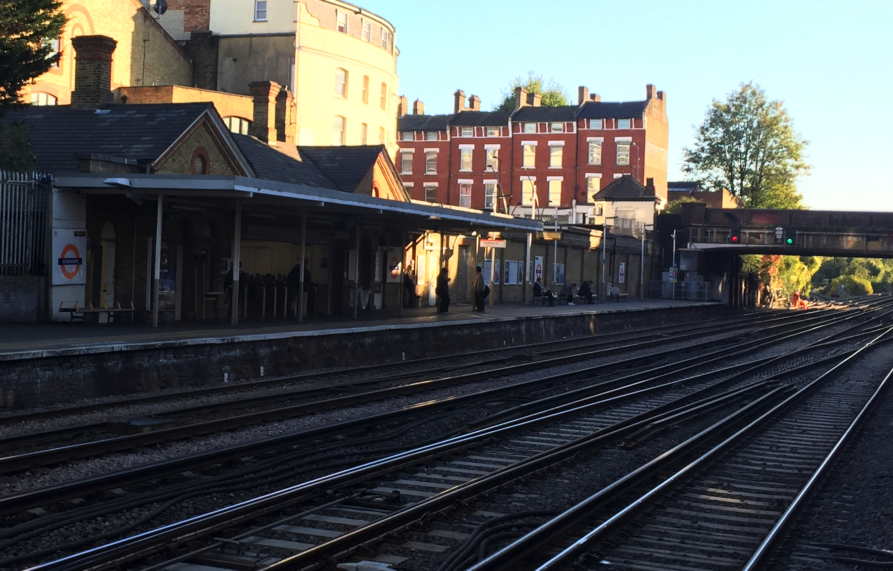
Below is a similar view from the up platform under the same lighting conditions. The little white building next to the bridge was the office for a business related to the railway, possibly a freight agent. The Heritage Audit recommends preserving it and two more like it on each side of the bridge at Anerley station.
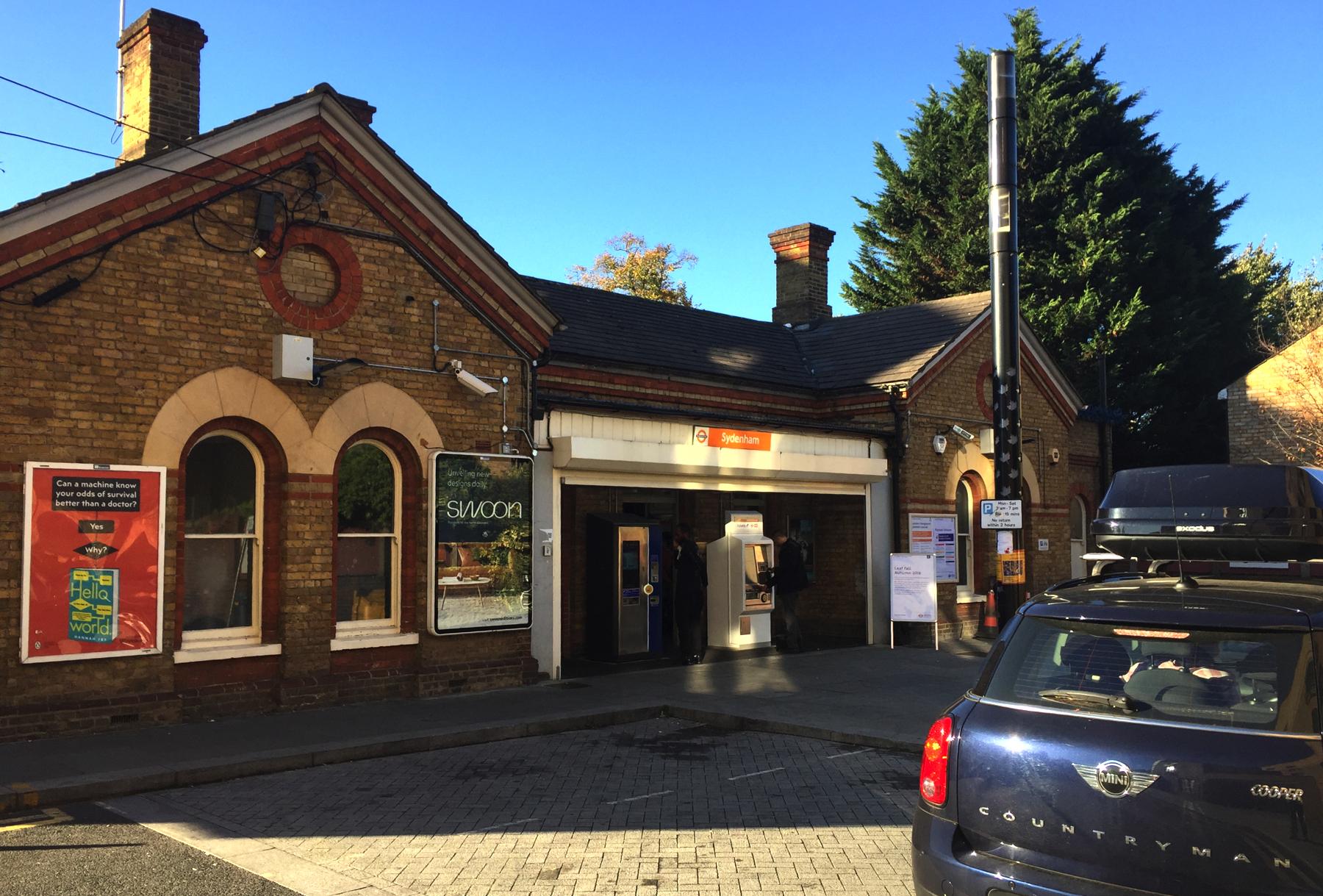
My picture of the street side shows a little more detail. I have seen other buildings in England with that motif of contrasting color bricks circling around not a window but just more bricks set back slightly from the main wall. Notice the same two colors in stripes below the roof.
PENGE
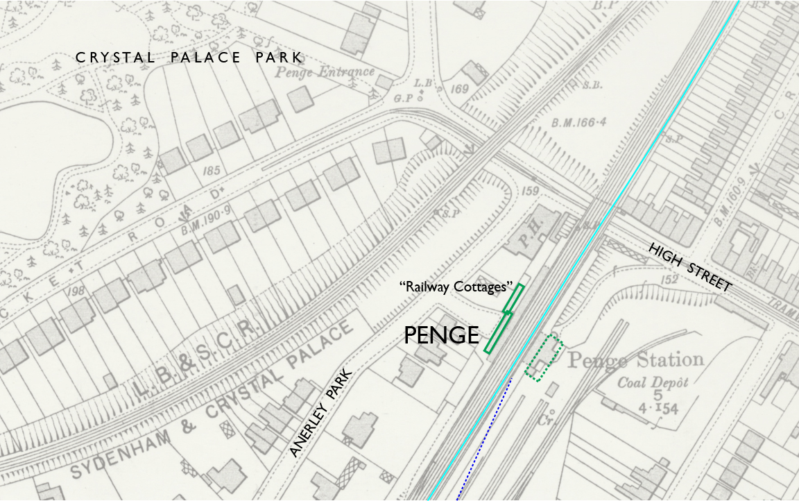
— Penge station, Ordnance Survey 25-inch, 1897. CC BY-NC-SA 4.0 courtesy National Library of Scotland.
Annotations by Joseph Brennan: atmospheric track (light blue line), and approximate center line of canal (dashed dark blue line).
Some modern writers say that there was originally a level crossing at Penge, but I do not think so. The road crossing was a place where the railway coincided with the site of the canal, which the road (then Beckenham Road) crossed over by bridge. By this point the straightened alignment from Sydenham had come back to the original. Howard Turner describes the grade of the railway as designed to continue on a steady rise to the south, enough to make it possible for the road to cross under "without too steep a fall". I am inclined to rely on his extensive research. At any rate there cannot have been a level road crossing of the atmospheric track.
As I mentioned, Penge was closed in 1841 after only two years and not reopened until 1863, so it was not a stop for the atmospheric railway. The two "steam" tracks were shifted to the west through this area so that the atmospheric track could be laid on the site of the original down line, and Howard Turner writes that the 1839 station, which he locates on the down side, "had no doubt been demolished preparatory to laying the atmospheric line".
The LB&SCR and the South Eastern Railway opened Penge stations on the same day, 1 July 1863. The Bradshaw railway guide and Stanford's maps unofficially called them Penge Bridges and Penge Lane. Like the two New Cross stations they were renamed in 1923 when they both came under Southern Railway operation, becoming Penge West and Penge East. This one, Penge West, had a large station house on the down side on railway land that was sold off around 1990 to become the site of a large store. Access now is only from the much more modest building on the up side. Someone committed a less legal form of destruction in April 2005 by setting the station on fire, but it was repaired and reopened in December 2006.
The photograph below shows the unremarkable one-story station building.
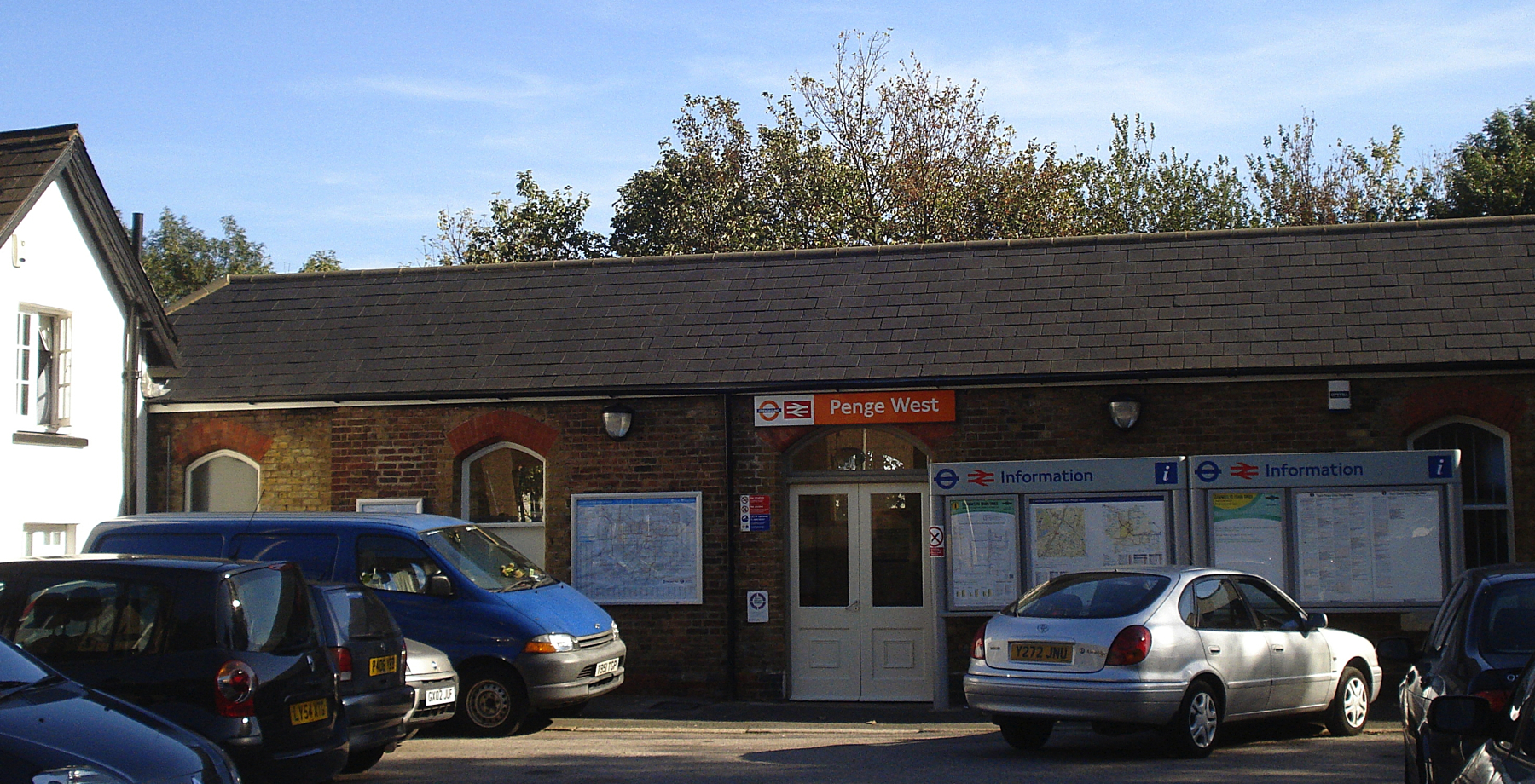
— photo by Kake (see london-road-croydon.org). CC BY-NC-SA 4.0. Statement of modification: some sky cropped out.
On the left is a mysterious white building that some people think is the 1839 station house. The Heritage Audit cautiously calls it "mid nineteenth century" and "of a charming cottage style with white rendered walls, dual-pitched slate roof and central chimney stack, together with a row of dormer windows facing the tracks" It is set back far enough to have been out of the way of the widening work in 1854, and its name is... wait for it... Railway Cottages. There were once railway cottages at Forest Hill in which company employees lived so that they would be close by if needed. Maybe that's what this was. Not now though. Each of the two units has sold for more than £300,000, and that's with dormer windows facing the tracks!
To keep the tall tale going, may I point out (refer to the map above) how nicely the approach roads on each side of the station lined up, as if they crossed the tracks there. The railway cottages are perfectly located on the north side of that theoretical crossing, and full-time protection would be needed at a level crossing, just as it was at Forest Hill. If we continue the broad curve it brings the theoretical road to the intersection located today at the Penge Entrance of the Crystal Palace Park. But let me remind you that Howard Turner has the station house on the down side.
This is why Penge West was nicknamed Penge Bridges. The nearer one carries the Crystal Palace branch. You can see how much height it gained in less than a mile. Although the High Street has to dip under the main line bridge, I think it would need to go up even more for a level crossing at that location. Q E D ?
ANERLEY
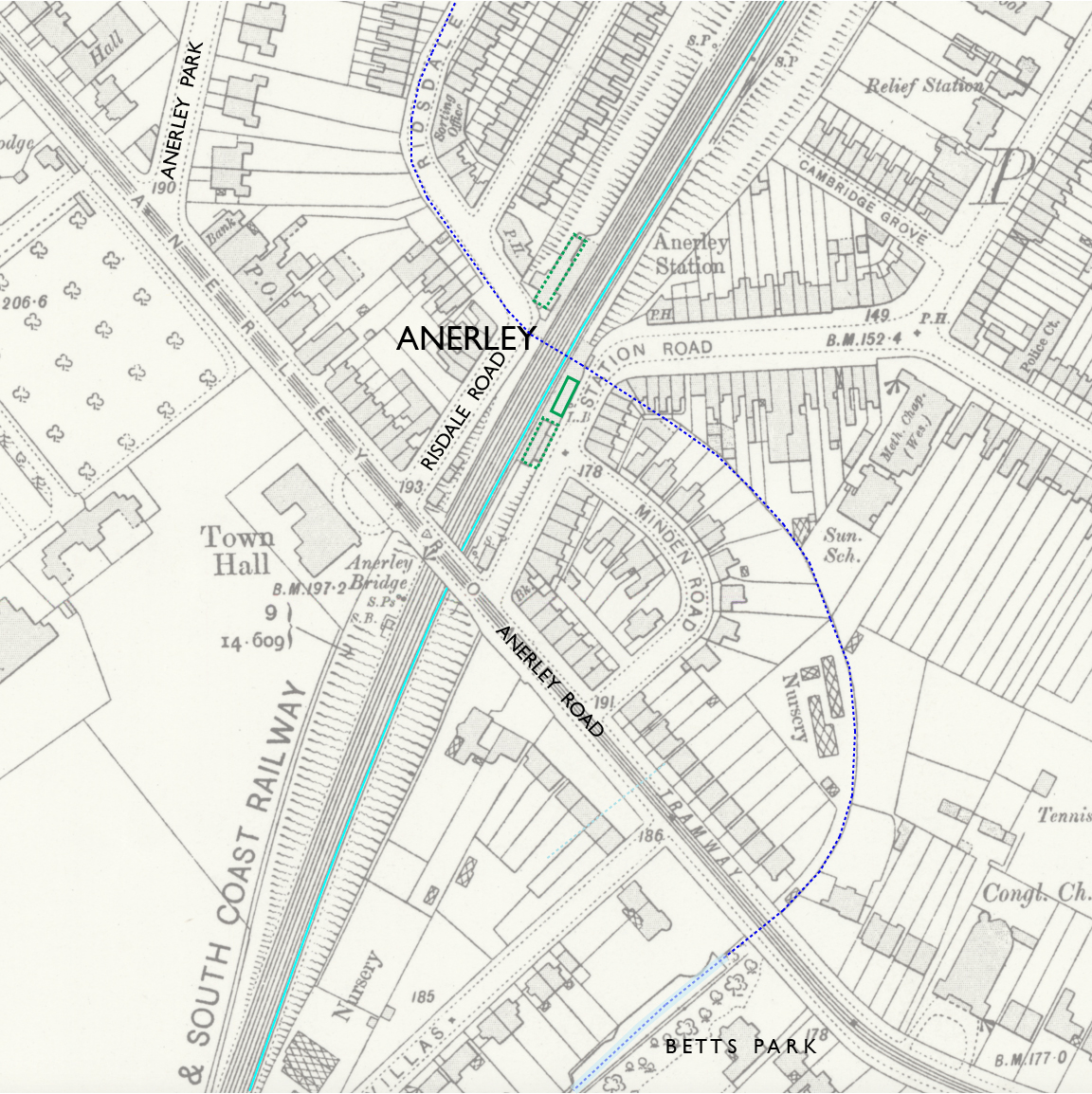
— Penge station, Ordnance Survey 25-inch, 1897. CC BY-NC-SA 4.0 courtesy National Library of Scotland.
Annotations by Joseph Brennan: atmospheric track (light blue line), and approximate center line of canal (dashed dark blue line).
Anerley is not much more than a mile from Sydenham (1 mile 15 chains). In 1839 there was scarcely any need for a station in between at Penge, except for that pesky unsourced story about a level crossing that I do not believe. Anerley itself was made a station only to comply with the wishes of a nearby land owner of Scottish ancestry who sold land willingly to the railway if they would put a station nearby, while admitting that his was the "anerley house" anywhere near it.
Howard Turner records that that the 1839 station was on the down side, like Penge. Therefore the "steam" tracks were shifted west, so that the atmospheric track would run past the station. The widening for four tracks in 1854 treated Anerley to new station houses on both sides, the larger one on the up side. Both of those were demolished about 1987, replaced by a new station house only on the down side with a footbridge to the up side.
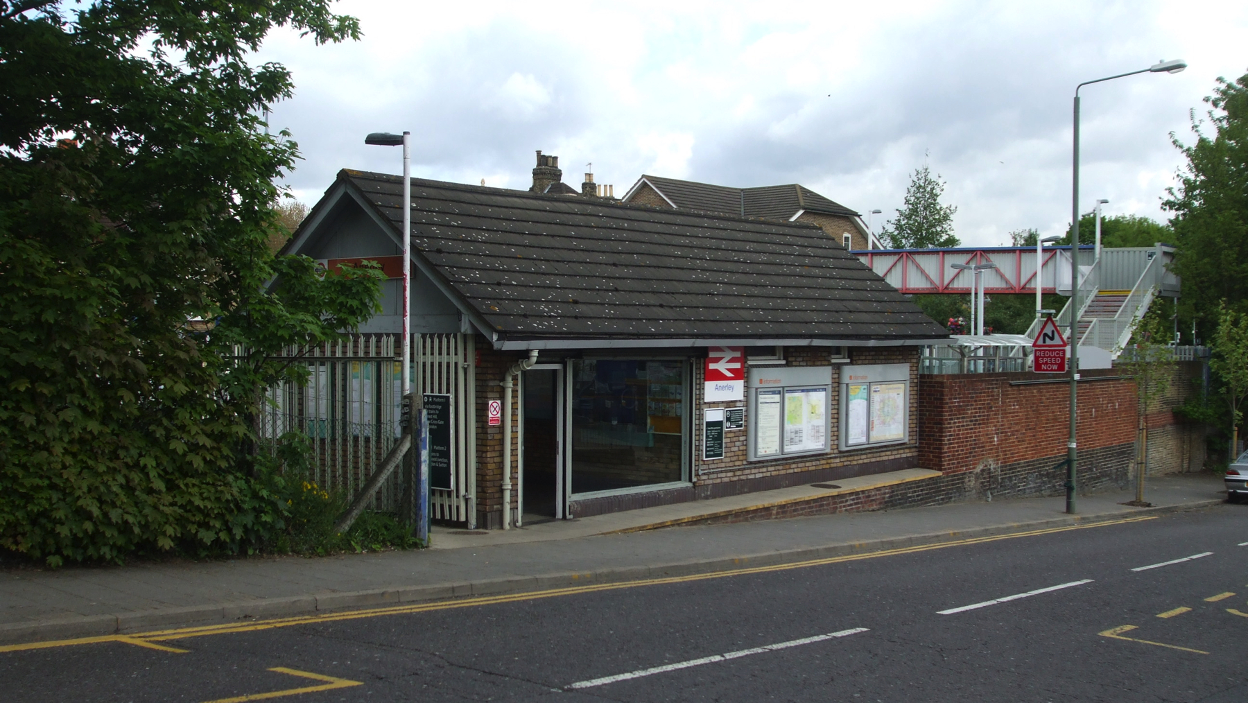
You might be wondering about so many station houses on the down side, when most passengers purchasing tickets and waiting for trains would be going toward London on the up side. It was less inconvenient then than it would be now, because passengers were simply directed to cross the tracks, so to that extent, every station was at a level crossing. Hadfield points out that the atmospheric trains made the risk even worse because the trains approached very quietly. The company tried installing what was called a "drawbridge" that would block crossing the atmospheric track, but still the company "policemen" sometimes raised it just in time. Howard Turner goes further, referring to "near escapes, and one or two fatalities, on the atmospheric line".
At the time I visited I knew no reason to leave the train at Anerley, and I was concerned about the fading light (see the Sydenham pictures). But there is something to see. If you walk a short distance southeast on the Anerley Road to Betts Park, there is a section of the London and Croydon Canal filled with water! It is now in a concrete channel, so arguably it is not perfectly original, but let that go, because it is in exactly the right place. The wildly swerving path of the canal here follows the contour of the land, preferring distance to locks.
NORWOOD
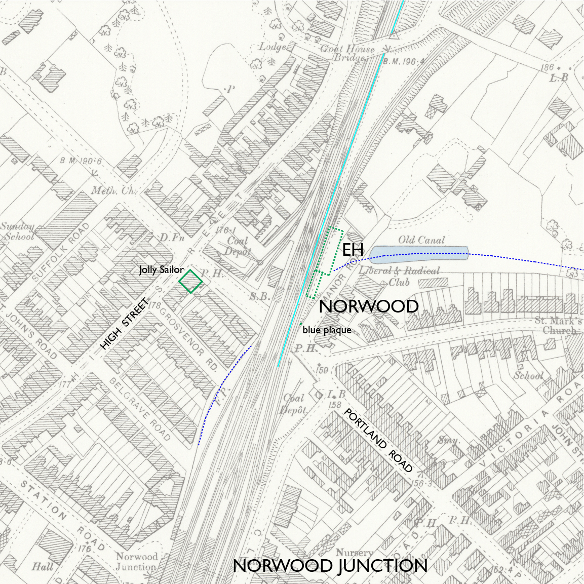
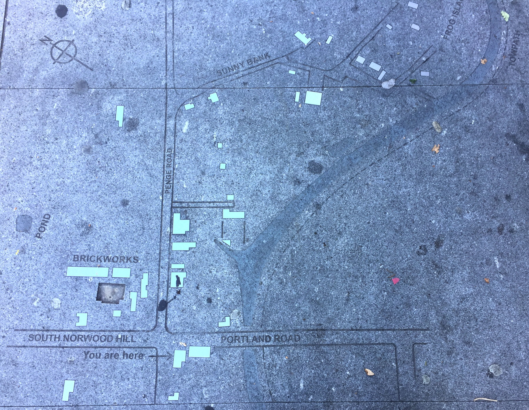
— Norwood station, Ordnance Survey 25-inch, 1897. CC BY-NC-SA 4.0 courtesy National Library of Scotland.
Annotations by Joseph Brennan: atmospheric track (light blue line), approximate site of engine house (EH), and approximate center line of canal (dashed dark blue line). Later changes south of Norwood station make it hard to determine where the atmospheric track was.
Norwood station was originally called "Jolly Sailor near Beulah Spa" where "near" meant two miles west of the station, but the spa, actually a property with many diversions for the upper classes in addition to a mineral spring, was probably the main basis for passenger traffic at first. The rename to Norwood on 3 July 1845 was no more honest, that place being a half mile farther up the hill.
The map above shows the original location of the station north of Portland Road and the present location of the Jolly Sailor public house. The up platform extended onto the bridge, and when the fourth track was added in 1854 the bridge was widened so that the up platform could still be there. The limitation seems to be the siding that prevented placing the up platform further north.
The Norwood engine house was north of the station. Early test runs in August 1845 looked very promising when it was shown that the Forest Hill and Croydon engine houses could create enough vacuum to pull trains the five mile distance without using Norwood at all. In normal operation some trains ran through without stopping, crossing the air gap by momentum. But how did the others stop, or rather, how did they start after stopping? My guess is that they stopped right after crossing the gap, although that requires a different length of platform for each direction of travel.
I have mentioned in the Forest Hill page the many problems that dashed those hopes during the first months, and the belief that they were resolved. Summer brought more troubles.
The year 1846 was unusually hot. The linear valve was sealed not only by suction pulling down the leather flaps but also by the use of a sticky "unctuous" mixture of beeswax and tallow that was supposed to glue the leather tight against the iron. In the heat the leather dried and became less flexible, and the sticky mixture melted. The valve leaked too much, and trains stalled for not enough vacuum ahead of them. The valve was not the same as that used on the Dalkey railway. As Hadfield describes it, Samuda had tried to minimize wear on the leather hinge by adding a thin steel plate, but it made things worse. The steel plate broke off and left a sharp edge that tore the leather. To correct the problem, atmospheric operation was suspended from 1 June to 13 July while the five-mile length of valve was rebuilt.
During this time the directors of the London and Croydon Railway and the London and Brighton Railway negotiated a merger that was approved on 27 July 1846, creating the London, Brighton and South Coast Railway. The directors joining from the Brighton company were not enthusiastic about atmospheric railways, and the troubles that summer strengthened their position. It was the combined directorate who decided against atmospheric operation on the Epsom extension.
Back to Norwood. The design of the engine houses was not good. I mentioned earlier on this page that the foundations had to be strengthened after they were in service. Hadfield reports that at Norwood the ornamental top of the stalk had to be removed as unsafe "almost as soon as the line opened for traffic." Here it is in its original form.
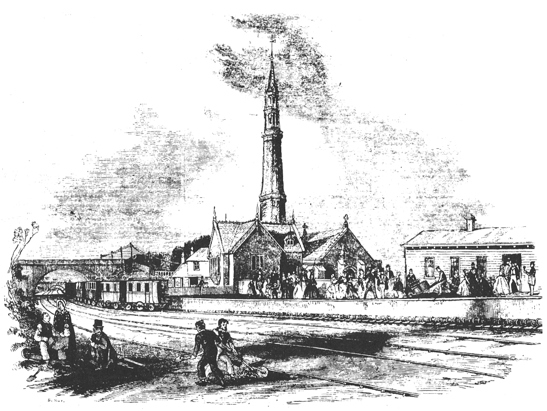
The wooden building on the right was the passenger station from 1839, striking a poor contrast to the architectural beauty that housed only machinery. Crossing over in the background is the Goat House Bridge carrying the Penge Road. The present-day Norwood Junction station is to the south of this location.
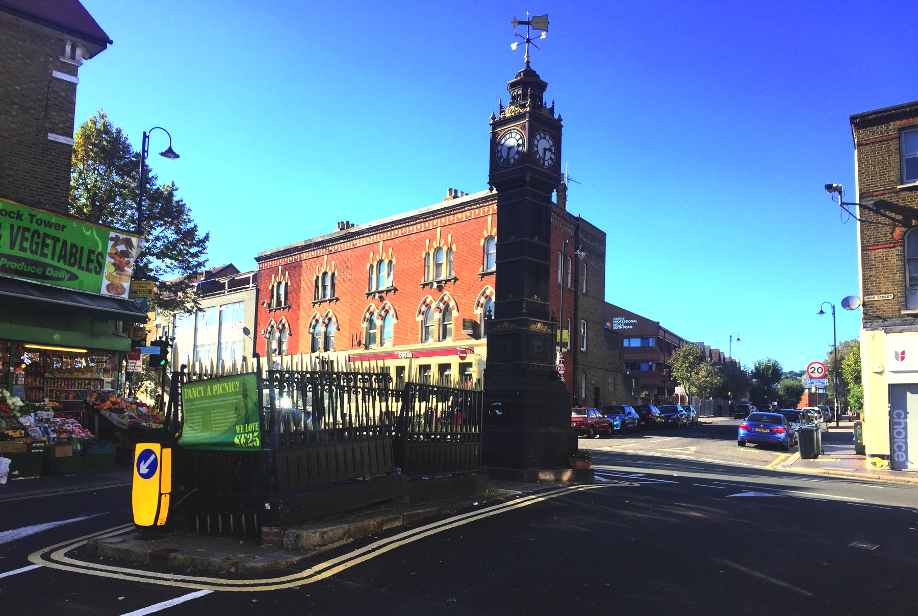
There are a few things to see. Go out of Norwood Junction station and up Station Road to the clock tower, and turn right at the High Street.
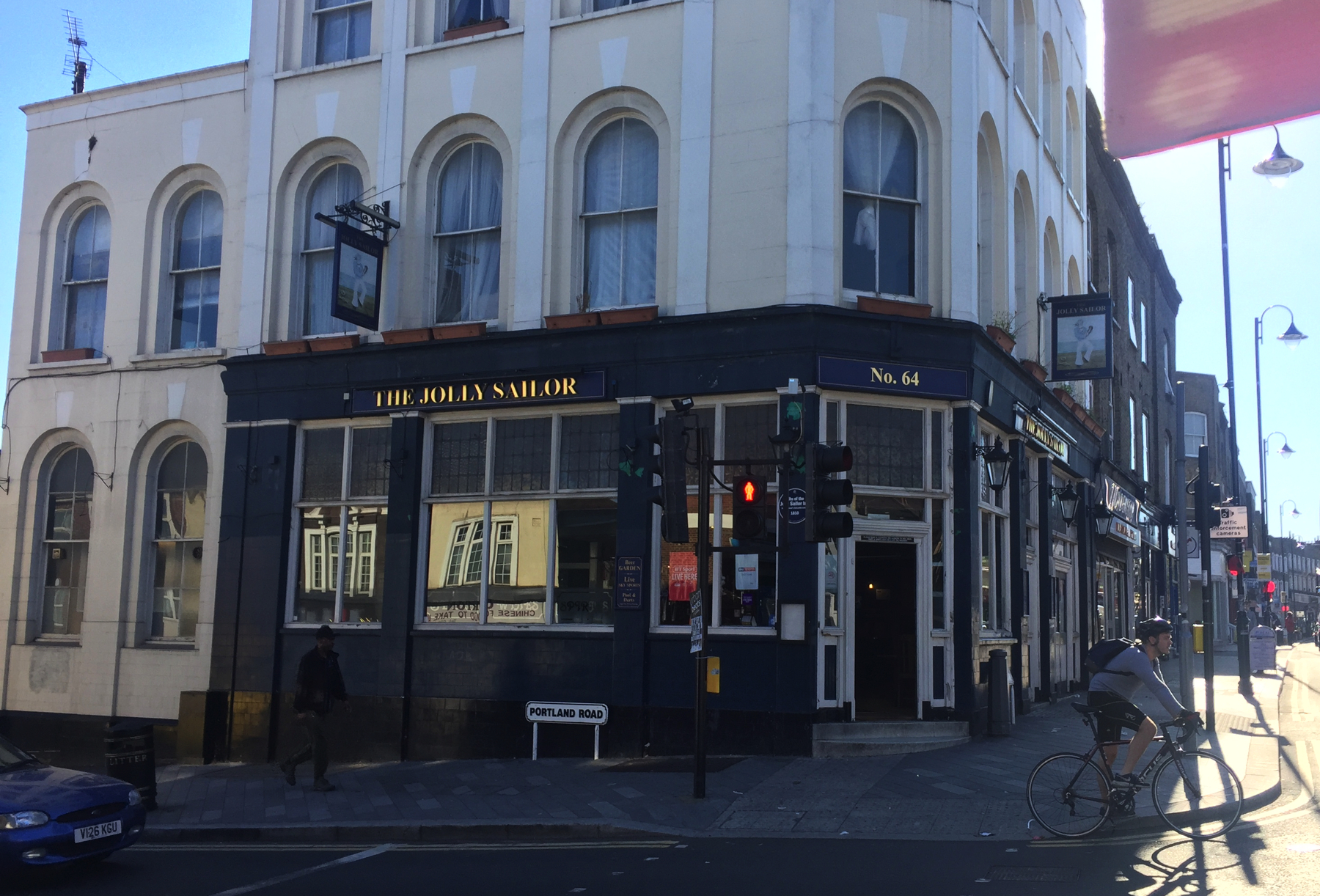
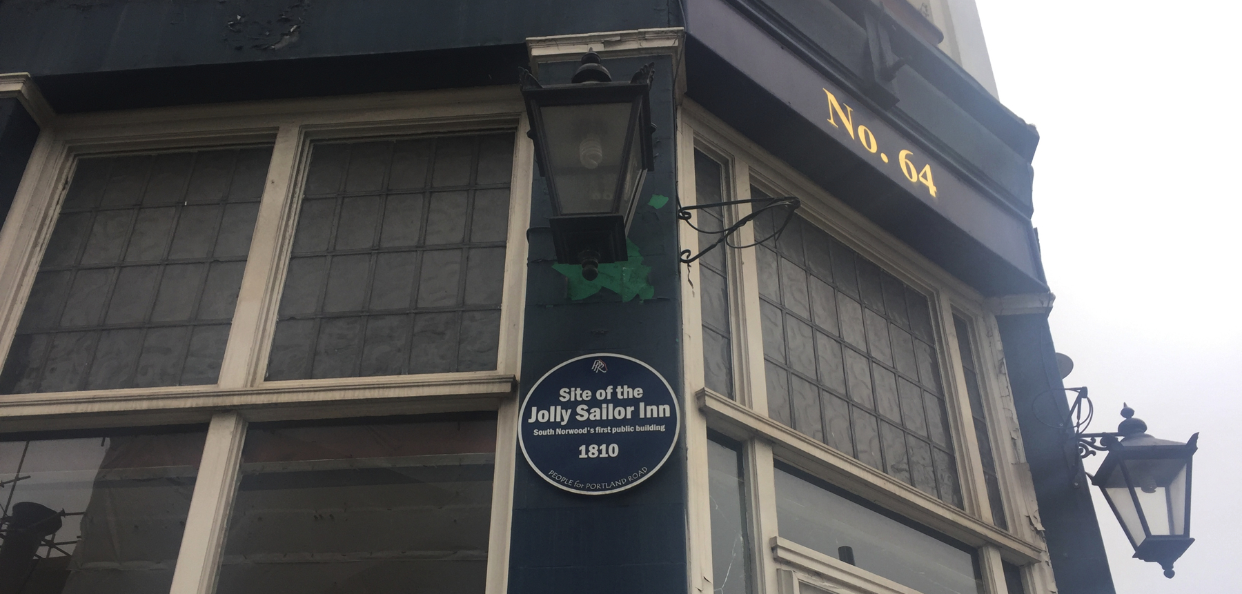
You will find at the corner of Portland Road some worn sidewalk blocks embedded with local history. There is the canal, and "You are here" is in front of the present-day Jolly Sailor, which was built about 1868 not far (if at all) from its old location.
Cross Portland Road and turn right, and take a good look back at the Jolly Sailor public house. It has a dark blue plaque commemorating its historial significance. There were no sailors here before the canal opened in 1809.
Walk down the north side of Portland Road, under the railway bridge, and turn into Manor Road. Take your life in your hands and cross Manor Road, and look back toward the railway. I did not have a telephoto lens and a tripod so this is the best I could do. There is a blue plaque on the bricks of the bridge abutment reading as follows:
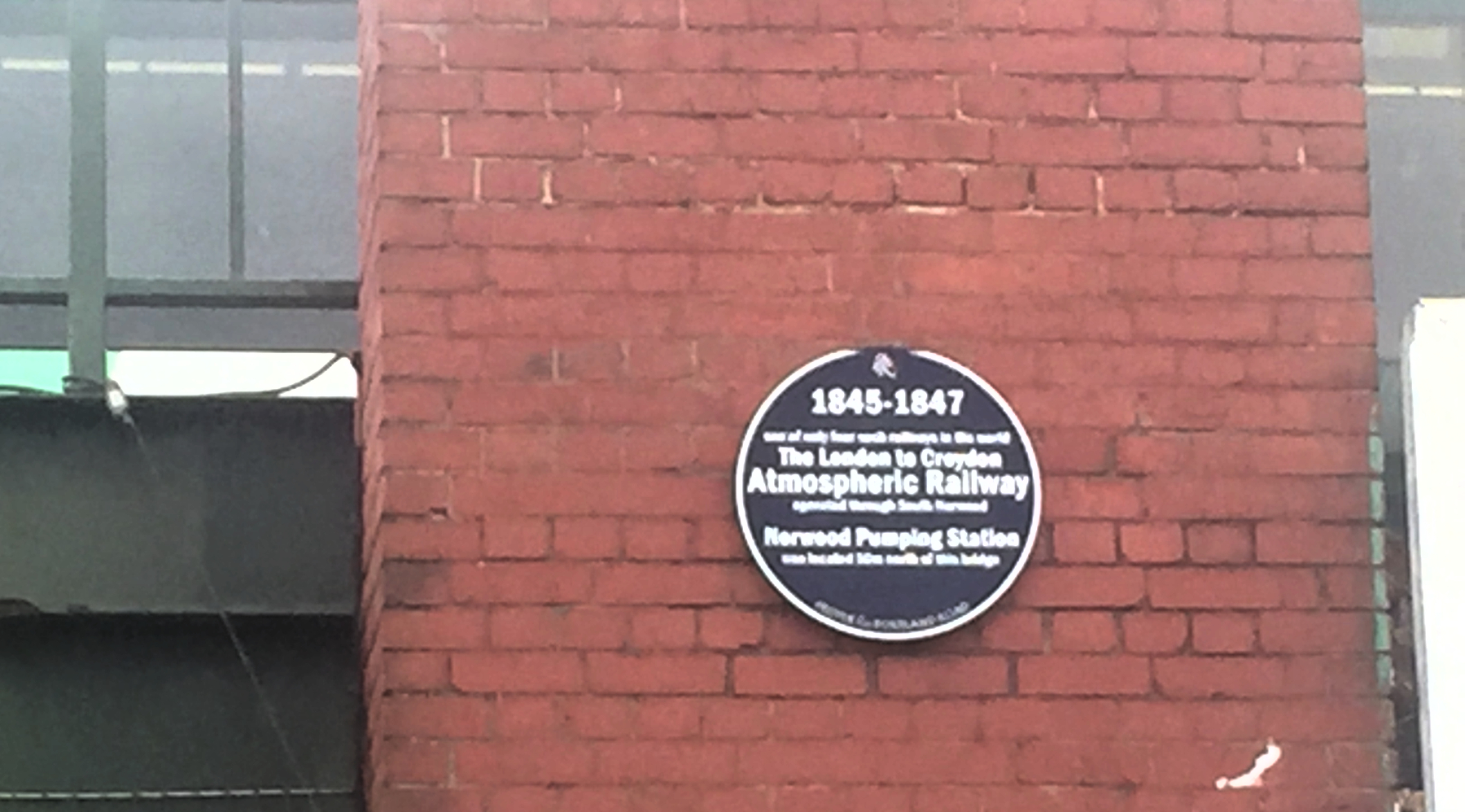
1845-1847
one of only four such railways in the world
The London to Croydon
Atmospheric Railway
operated through South Norwood
Norwood Pumping Station
was located 50m north of this bridge
PEOPLE for PORTLAND ROAD
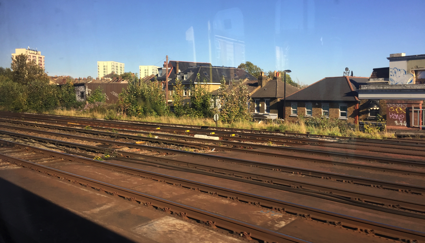
Finally, below is a view of the Norwood station site from the train window. The floor of the Portland Road bridge is in the foreground. I think the station was located right about the middle of the picture, and the engine at the bushes to the left. There is nothing to see but this.
NOTES
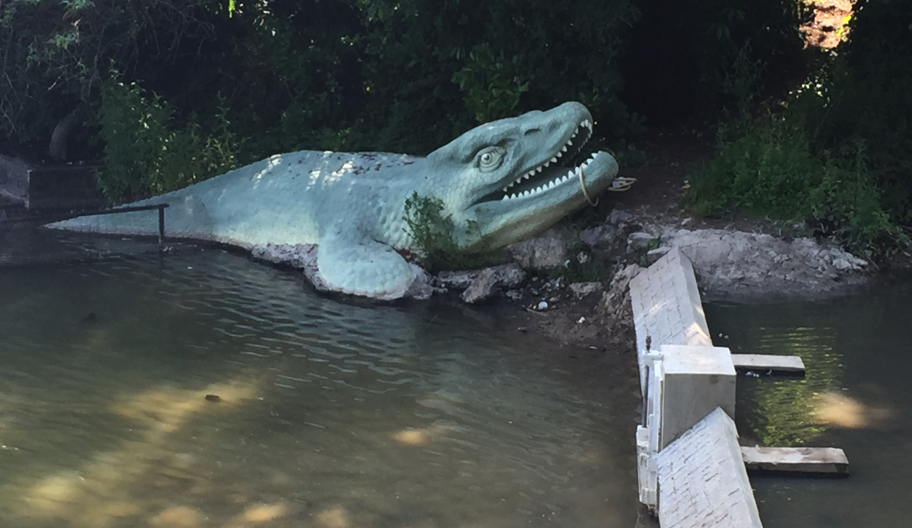
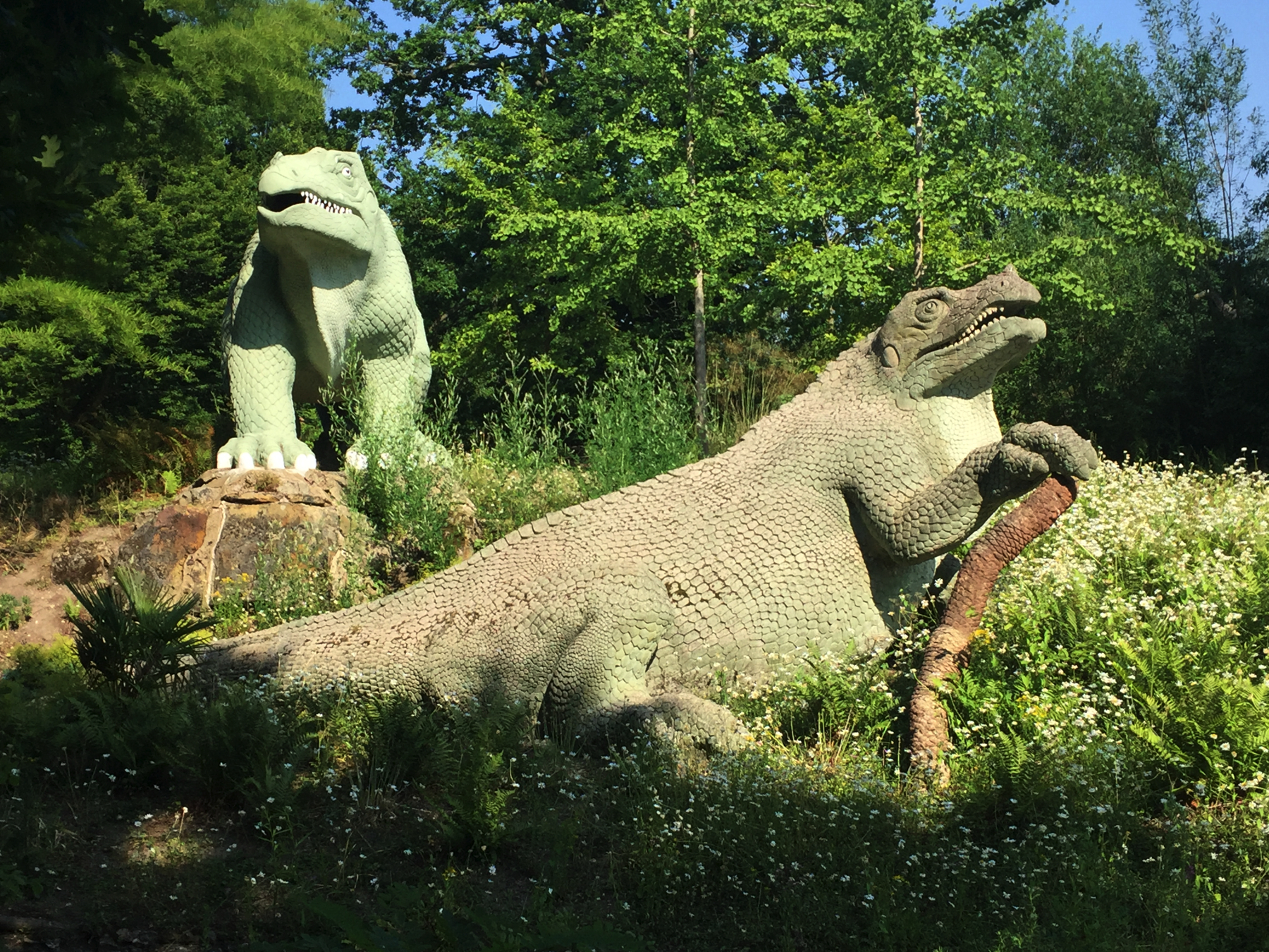
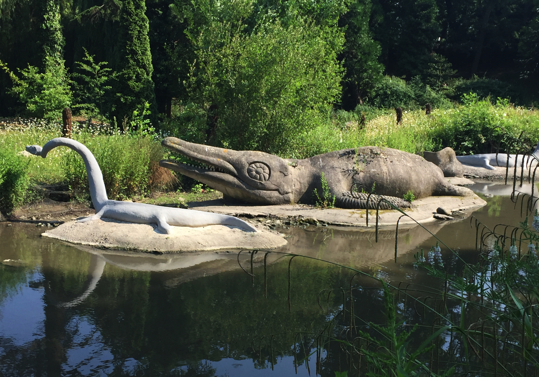
Not too long after the atmospheric, in 1854, the Crystal Palace opened, along with the LB&SCR branch line to a special station nearby. Among the marvels in the grounds were life-size models of dinosaurs, made by Benjamin Waterhouse Hawkins in cooperation with the noted palaeontologist Richard Owen, according to the latest knowledge of the day. An obstacle to scientific progress was the very early idea that dinosaurs were reptiles, which was hard to shake even after the realization that some of them were bipedal. Some of those were sculpted here on all fours, and of course not one was shown with feathers.
The models fell into neglect after the Crystal Palace burned down in 1936, but they were renovated in 1952 and again in 2002. There is now a charitable foundation dedicated to preserving them, and in 2007 they were made Grade I listed buildings (for want of a category for this sort of thing).
But why do I mention this? If you want to take a break from looking at places with no remaining evidence of the atmospheric railway, get off at Penge. It's a very short walk to the park gate and a very short walk again to the dinosaurs. Coming in from here, you will be viewing evolution in reverse, starting with early mammals. If that bothers you, change at Sydenham for a train to Crystal Palace and walk in from there. I enjoyed seeing the models very much, so let me put in a few of my photographs. That scaly skin!
TODAY'S ETYMOLOGY
Sydenham is pronounced "siddinnim" or even without the middle syllable. The name may be from Old English sid, "broad" or "wide", and ham, "place", cognate with modern English "home". But some sources credit a personal nane Cippa and ham.
The name Penge is said to be Celtic and cognate to the name of the Welsh town Pencoed, which is said to be pen, "head" (often as "hilltop" or "end" in place names) and coed, "trees", thus pen y coed, "edge of the woods". I'm not totally happy with that for Penge because the second part is so shortened. The second part coed is pronounced "coyd" in Welsh, and we might want to say that the vowel in "coyd" softened the syllable to "joyd" at some point and then the "oyd" was lost. I don't know. The Cornish place name Pengelly, the second part meaning "grove" (with a hard "g") might make as good a cognate as Pencoed.
The story holds up that the Scotsman William Sanderson bought land in the formerly open Penge Common and named his house Anerly because it was the only one for some distance around. After the railway opened, a resort called Anerley Gardens was established near the station, along the scenic canal. The plumbing businessman Thomas Crapper lived in Anerley.
Norwood recalls in its name the Great North Wood, an old oak forest that stood on the southern edge of London until housing construction removed most of it in the nineteenth and twentieth centuries. Norwood refers to a large area of which the railway station is in the part called South Norwood. Upper Norwood (for its hilltop location) was the site of the the Beulah Spa resort and is just west of the Crystal Palace Park. The circus star Pablo Fanque performed at the Beulah Spa in 1834.