South Devon Railway
Countess Wear
In which Joe contemplates a remote site in the marshes along the River Exe.
Explorations: 26 June 2018, 28 June 2019.
Journey: Paddington to Exeter St Davids, St Davids to Starcross.
-
OFTEN CITED REFERENCES
- Paul Garnsworthy, editor, Brunel's Atmospheric Railway, The Broad Gauge Society, 2013.
- Peter Kay, Exeter–Newton Abbot: a Railway History, Platform 5, 1991, and excerpts in Garnsworthy.
- Howard Clayton, The Atmospheric Railways, the author, 1966.
- Charles Hadfield, Atmospheric Railways, David and Charles, 1967.
- G.A. Sekon, A History of the Great Western Railway, Digby, Long, 1895.
The second engine house on the South Devon Railway was called Countess Wear. It's the first one we encounter that was not at a station. The site was far from population and not even next to a road, but the atmospheric railway needed power about every three miles, so here we are. To this day it is an isolated spot. The place called Countess Wear is on the other side of the River Exe.
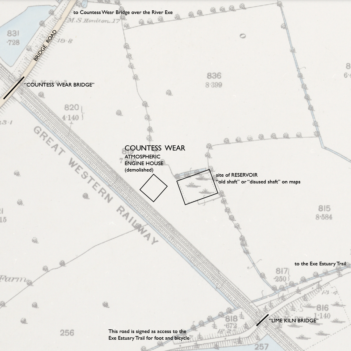
— Countess Wear engine house, Ordnance Survey 25-inch, 1890. CC BY-NC-SA 4.0 courtesy National Library of Scotland.
Annotations by Joseph Brennan.
The OS map from 1890 is still good today. Nothing has been added. Even the field boundaries are the same. Bridge Road still carries traffic, on a wider bridge at the same site. The Lime Kiln Bridge no longer brings wagons to lime kilns on the riverbank, but the old road is still there, and even the trace of its pre-railway straight path.
Below is a detail from Google Satellite view. I have inserted the same rectangles for the engine house (left) and the reservoir. Allow for error, but it is about right. The field boundary at the lower left here matches the line between L and W on the map.
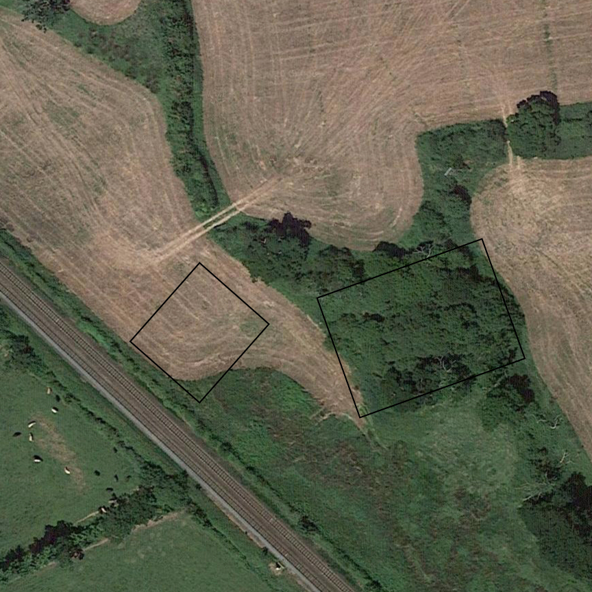
Google : imagery © CNES / Airbus, Getmapping.plc, Infoterra Ltd & Bluesky, Maxar Technologies, 2020. Annotations by Joseph Brennan.
Thanks to William Dawson's drawings we have a plan for the exact location of the engine house within the constant field boundaries. It is the best clue we have. The book Brunel's Atmospheric Railway reports that the Society has been to the unpromising site. "A preliminary investigation has however revealed a circular feature of about 21 feet diameter next to the engine house, perhaps connected with the water supply."
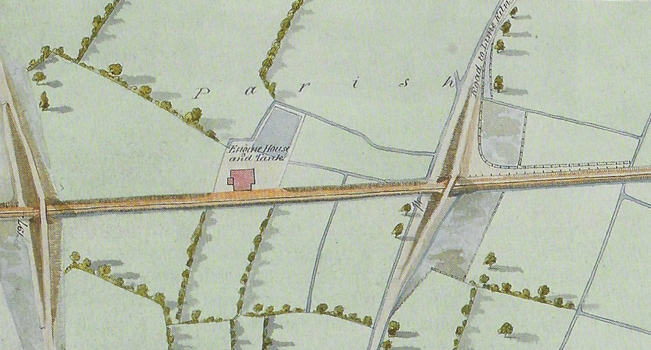
mdash; William Dawson, via Brunel's Atmospheric Railway.
"Engine House and Tank", it says. The reservoir for the steam engine is the only remnant, noted on some Ordnance Survey maps as "old shaft" or "disused shaft". I wonder how deep a shaft it could be in this water-logged landscape. It's probably a misnomer for an unplumbed but persistent pool. Other OS maps, like the 1890 one I supply above, show it with the symbol called "osiers", willow trees. Lastly, I notice that Dawson's Mile Post 197 is almost 11 chains farther than that on the 1890 map (off the borders of the detail I show above).
Dawson also gives us the only image of the engine house.
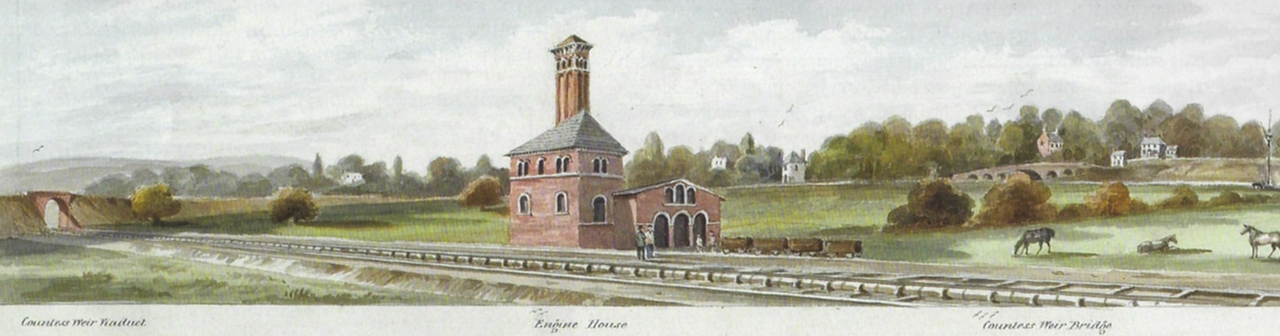
— William Dawson, "From Countess Wear to the Exminster Marshes", detail, via Brunel's Atmospheric Railway.
Next to the boiler house are four coal wagons. The only way they could get here is by rail. There was definitely a gap in the pipe here, between the Exeter–Countess and Countess–Turf sections, but Dawson does not show it to us. That gap woud be the place for a switch or a turntable to get the wagons off the main line. On the left under one gull is the Bridge Road bridge over the railway, a simple arch called "Countess Weir Viaduct" by Dawson, and toward the right, farther away, under three gulls, is the Countess Weir Bridge over the Exe. (Dawson spelled "weir" correctly, or not correctly.)
Atmospheric trains crossed the gap at speed, 50 miles per hour or more. "Not good for the piston", it has been said. On the London and Croydon, a few trains were scheduled to pass the gap at the Norwood engine house without stopping, but the South Devon trains ran at a higher speed and no passenger trains stopped at this engine house.
Nothing is visible today from the train, which runs very fast past this location, on the longest straight on the entire South Devon Railway. If you want to gaze upon the site, here is a guide.
From Exeter St Thomas: Ride on the left-hand side. Wait until there are no more buildings near the line on the right-hand side. The first overbridge is the "Countess Wear Bridge" where you pass under the aptly named Bridge Road. After that, look out on the left for a thick stand of trees on the far side of a field. The stand of trees is around the reservoir, and in the foreground is the unidentifiable site of the engine house.
From the south: Ride on the right-hand side. Wait for the double bridge of the M5 crossing over. The next overbridge is the small "Lime Kiln Bridge" for a one-lane road. After that look out on the right to the stand of trees as described above.
Below is a driver's eye view from a train running north, immediately after passing under the Lime Kiln Bridge. The clump of trees in the right distance marks the site of the reservoir. Nothing can be seen of the engine house, which would be within the approximate space I have indicated. The railings in the foreground protect the sides of a culvert over a drainage ditch.
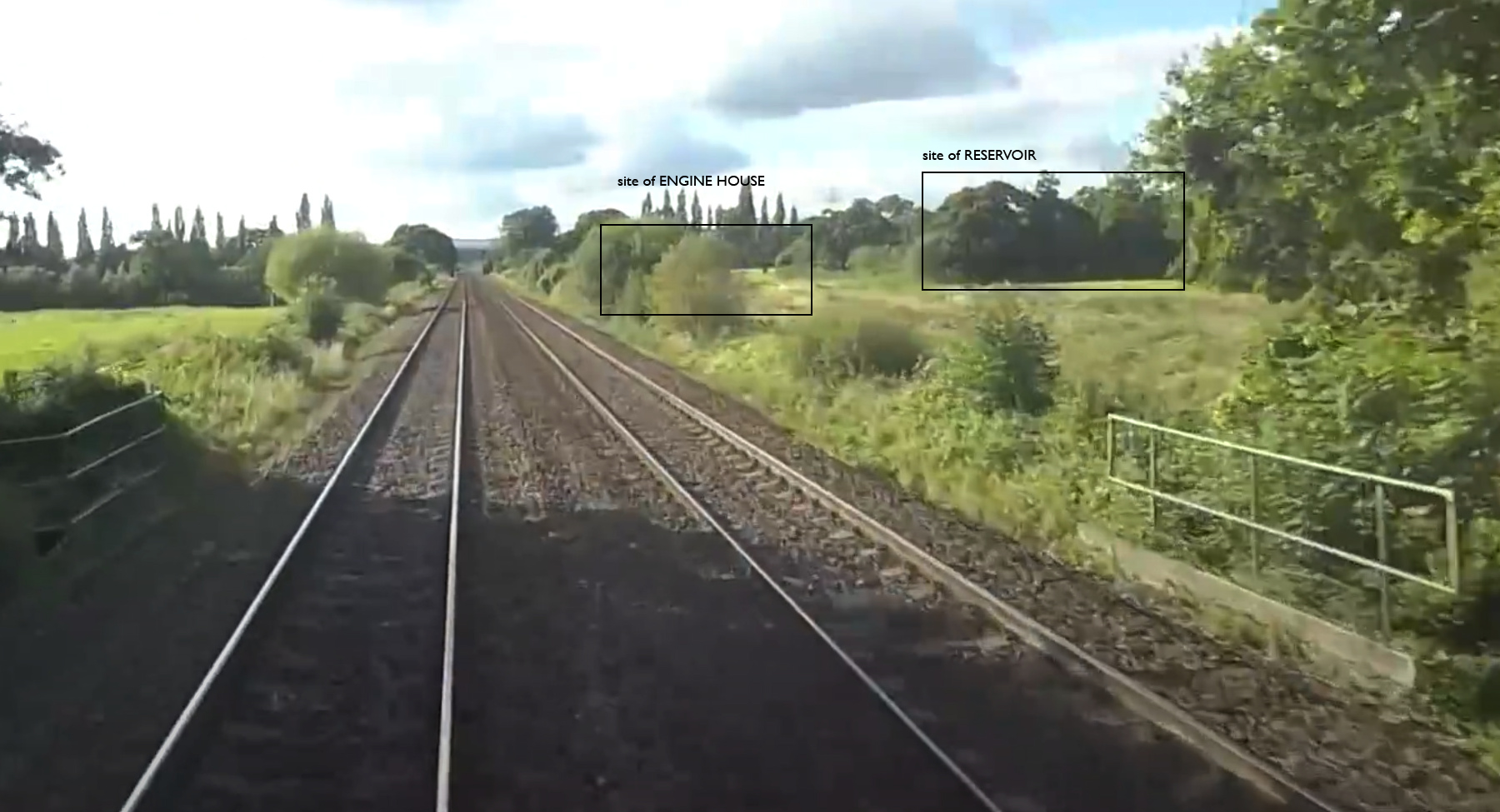
— "A Drivers Eye View from Paignton to Exeter St Davids...", screen cap at 36:12, from Railmart Ltd on Youtube. Probably 2019 or 2020. Annotations by Joseph Brennan.