Extra
Plymouth Railways
In which Joe tries make sense of the railways at Plymouth.
I was on the ground at Plymouth only once, taking a short walk to kill 45 minutes until I could board a train stopping at Saltash, where I detrained in order to get some pictures of Brunel's Royal Albert Bridge. I suppose on some other occasion I could have given Plymouth more of my time. Since I have pictures of the Mayflower pub in Rotherhithe, it might be fun to figure out where the ship of that name picked up passengers in 1620, if anyone knows the place, and get a picture there, and then back in the States, I could go up to Massachusetts to snap the landing site to complete a triptych. But why would I do that?
I have found the local railway history of Plymouth to be very complicated and hard to follow, even though only three railway systems were involved. The main player since 1848 was the Great Western, at first in the form of three companies, namely the South Devon, the Cornwall, and the South Devon and Tavistock. Second, the competitor from 1876 was the London and South Western, which had confusing sections of joint trackage with the Great Western. Third and chronologically first was the Plymouth and Dartmoor Railway, a horse tramway that played a surprisingly big role in the story up to 1960. Naturally the three had different gauges: Great Western lines 7 feet ¼ inch, South Western 4 feet 8½ inches, and Dartmoor 4 feet 6 inches.
The Plymouth area is very hilly. You need to know that in order to understand the sometimes circuitous routes taken by the railways.
To sort it all out I started making a map and notating when each part was opened. The result is here. I decided to use a dashed line for tunnels, and a thinner line for non-passenger lines, which left me with neither method of showing abandoned lines. But there is so little in use today that I can describe it easily:
Passenger trains use the former South Devon and Cornwall main lines, entering the map area at Plympton on the right and leaving beyond Saltash on the left, with one branch, a local service on the former South Western line branching off at St Budeaux Junction and running off the map at upper left. There is some freight trackage in use along the River Plym, right center, down almost to the site of Friary and Laira. Lastly the Plym Valley Railway runs a short heritage line from Marsh Mills to Plym Bridge, upper right.The only large station is Plymouth, originally Plymouth North Road. The next station east is twelve miles away at Ivybridge, but to the west there are five small stations within six miles to Saltash. The area to the east close to the railway is less populated. The Plymouth station is not well sited for local travel, being nearly a mile north of the city center. The one-time Millbay and Friary were not much better, almost as far west and east respectively. The hills were a factor, but also land costs in built-up port town centers that pre-date the railways by centuries.
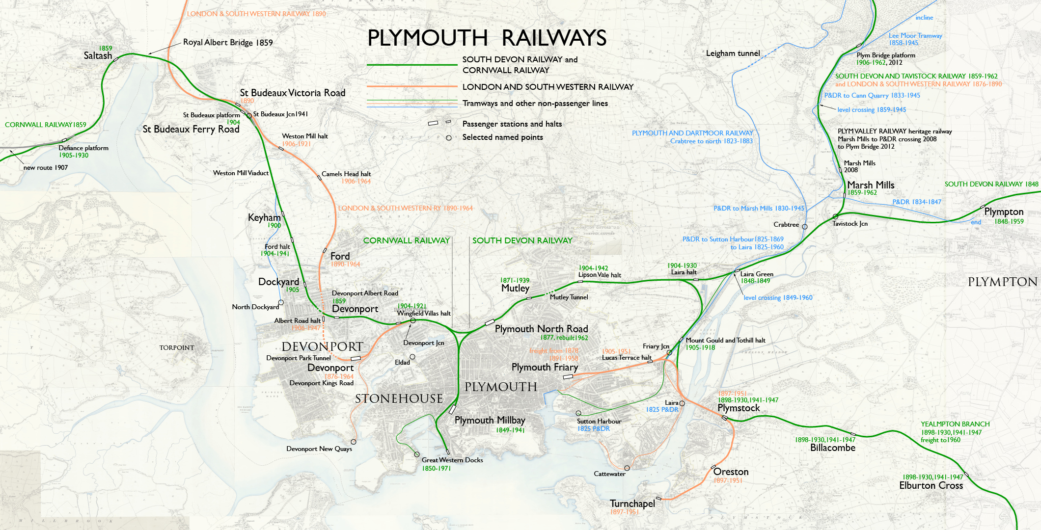
— Map by Joseph Brennan © 2020. Sources include Wikipedia articles and Old Plymouth.
Base map: Ordnance Survey 25-inch, various dates. CC BY-NC-SA 4.0 courtesy National Library of Scotland.
CHRONOLOGY
1823. Plymouth and Dartmoor Railway opens from King's Tor (far north from my map border) down to Crabtree on the River Plym. This is a pre-locomotive tramway with wagons pulled by horses, and no passenger service. It was more important to limit the gradient than the curvature, with the result seen on my map.
1825. The Dartmoor is extended south to Sutton Harbour and Laira dock. Both provide better shipping connections than Crabtree, which was good only at high tide.
1830. The Dartmoor opens a short branch with a bridge over the Plym to Marsh Mills, to exchange freight with the Earl of Morley's canal along the east side of the river.
1833. The Dartmoor operates north on the Earl of Morley's railway, built on the former towpath, to his Cann Quarry a short way off the top of my map.
1834. The Dartmoor operates east to Plympton on a side-of-road tramway, to connect with the Earl of Morley's pack horses bringing china clay from the moors up north.
1840. The South Devon Railway plans to build to Plymouth, but to minimize grades by staying on high ground on the north side. The terminus will be at a place called Eldad (location shown on my map) that may be a compromise location among what were then three separate towns: Plymouth, Devonport, and Stonehouse.
1846. The Cornwall Railway plans to build from Eldad, with a train ferry across the Tamar to Torpoint (named on my map).
1846. The South Devon obtains powers to purchase the Dartmoor's branch to Sutton Harbour but does not reach an agreement to do so for several years.
1847. The Dartmoor's operation to Plympton is abandoned by the Earl of Morley, to avoid a crossing with the South Devon, with which he plans to connect instead.
1848, 5 May. The South Devon opens to a temporary terminus called Laira Green, and no further because of a dispute with mortgage holders of the Dartmoor, who unload granite boulders on each side of their railway to block the South Devon. The station and end of track were a few feet east of the intended crossing, from which carriages carried passengers by road into Plymouth. The South Devon blamed the delay on finishing the Mutley Tunnel, and that may have also been a reason. A settlement with the Dartmoor was reached within the year.
1849, 2 April. The South Devon opens to Millbay, at this date the only passenger station in what is now Plymouth. Laira Green was abandoned. At the level crossing with the Dartmoor, wooden boards were laid around the South Devon rails for the horses to walk upon.
In A History of the Great Western Railway Sekon mentions the proposed "branch to Mill Bay, Plymouth (67 chains long), which had a fall of 1 in 24, and was not proposed to be worked by locomotives." Even at the time Brunel was planning for atmospheric operation, a grade of 4.2% was preposterous. I have not been able to find information on the grade that was actually built, but it cannot have been that steep. In addition to passengers the branch handled freight trains carrying loads to and from the docks.
1850. The South Devon is extended to the docks near Millbay for transshipment of freight.
1851. The South Devon purchases the Dartmoor's Sutton Harbour branch for joint operation by horse power. Three-rail track was laid for the two gauges. The South Devon had its own broad-gauge sidings south of the crossing and facilities to stable horses and locomotives. Track was re-laid in 1857 but it continued to be operated by horse. The Dartmoor's other branch to Laira dock was not part of the purchase.
1852. The South Devon negotiates with the Earl of Morley to acquire his railway on the east bank of the Plym (operated by the Dartmoor) and to operate a new tramway with an incline down from his Lee Moor china clay mines. To do this the South Devon and Tavistock Railway was authorized in 1854, to be built of course to broad gauge, but the Act had a provision inserted that should a narrow gauge line ever connect itself, the company would be obliged to admit the narrow gauge (that is, standard gauge) upon their railway. This unwanted clause became important later. Negotiations with the Earl failed, delaying work.
1854. The Cornwall Railway begins construction of the main line to Truro, including the major work that would be named the Royal Albert Bridge.
1856. The South Devon and Tavistock Railway begins construction. From Marsh Mills to Plym Bridge it was not built on Morley's railway but follows it very closely and crosses it on the level about halfway to Plym Bridge platform.
1858. The Earl of Morley opens the Lee Moor Tramway with through running into his railway run by the Dartmoor. The incline shown on my map was operated by gravity, presumably hooking wagons to a chain, so that loads of china clay coming down pulled up the empties.
1859, 4 May. The Cornwall Railway opens from Millbay to Truro. At a ceremony two days earlier the Prince Consort opened the bridge at Saltash that was named in his honor. The line as far as Devonport station, opened the same day, was built under South Devon powers but was transferred to the Cornwall company. Note: the chord from the South Devon to the Cornwall, bypassing Millbay, was not built at this time.
1859, 22 June. The South Devon and Tavistock Railway opens from Tavistock Junction to its namesake town quite a bit north of the border of my map. Trains ran from Millbay, and to accommodate the additional traffic of the two new railways, the South Devon bit the bullet and added a second track from the terminus up to the junction with the Cornwall.
1865. The Tavistock is extended to Launceston in June, almost doubling its length. A month later the South Devon Railway merges the Tavistock. The South Devon had operated it since it opened.
1869. The South Devon becomes sole operator on the Sutton Harbour branch, and can start using locomotives on it. The Dartmoor still has the line to Laira dock.
1871. The South Devon opens the second station in Plymouth at a location called Mutley, just west of the tunnel of that name. It is at a summit, so I wonder whether the land may have been acquired years earlier for a never-built engine house.
1874. A new player in the game, the Devon and Cornwall Railway, opens to Lidford, a place on the Launceston extension of the Tavistock. It was no secret that this company was acting for the London and South Western Railway by building its route from Exeter around the north side of Dartmoor, reaching Okehampton in 1871 and coming south to a terminus at Lidford three years later. Under the Tavistock's Act of 1854, its successor the South Devon was now obligated to provide a third rail, at least as far as Tavistock Junction. The Devon and Cornwall planned to build a new railway from Marsh Mills to Plymouth and Devonport, but surprisingly the Great Western was willing to handle the South Western passenger trains and create a union station that became known as Plymouth North Road. Construction on that plan began in 1874.
1876. The Great Western Railway merges the South Devon Railway. The Cornwall remained separate for thirteen years more.
1876, 17 May. London and South Western trains begin operating to Plymouth. Coming off the Tavistock branch, trains run on the former South Devon, stopping at Mutley for Plymouth. Then they run on a new chord built by the GWR called the Cornwall Loop, avoiding Millbay. After going a very short distance on the Cornwall Railway the trains come to Devonport Junction, where they gain London and South Western metals, and in another short distance reach the South Western's own terminus. It is called Devonport, the same name as a nearby Cornwall Railway station. (Eventually Devonport L&SWR was called Devonport Kings Road, and Devonport GWR was called Devonport Albert Road— which was still confusing because the L&SWR opened an Albert Road halt even closer to Devonport GWR.)
1877, 28 March. North Road joint station opens for both railways. It became the main station at Plymouth, and the Plymouth station today is on the same site.
1878, 1 February. The South Western opens a freight terminal on the east side of Plymouth at Friary. To reach it, trains run a short way on the GWR Sutton Harbour freight branch and then on their own metals.
1879. The South Western extends the Friary branch by a very short tunnel and street track to reach Sutton Harbour. There it meets street track from the GWR Sutton Harbour branch, and joint use from that point is soon arranged.
1880. The South Western opens the curve from the Friary branch into a new freight branch to Cattewater.
1882. Great Western boat trains begin running between the docks at Millbay and Paddington. It was advertised as cutting a day off travel time to London. I show a passenger station there, but no standard tickets were sold for it, because it was used only to transfer passengers. Special tickets were available for people to go there to meet friends arriving from ships.
1883. The Plymouth and Dartmoor Railway abandons most of the original line north of Crabtree, including the Leigham Tunnel. The company still operates the Earl of Morley's lines, and their own line from Marsh Mills to Laira dock. This year the Dartmoor obtains powers to bridge the Plym near Laira and build a branch down to Turnchapel. The South Western was a party to the plans.
1887. The Dartmoor opens the Laira railway bridge and a short distance farther to Plymstock, called Pomphlett until 1892.
1888. The South Western runs freight over the Dartmoor's Laira bridge to Plymstock.
1889. The Great Western Railway merges the Cornwall Railway.
1890, 2 June. The South Western opens an independent route to Plymouth, using (take a breath) the Plymouth, Devonport and South Western Junction Railway from Lydford to Devonport. This comes in at the upper left corner of my map. Running along the River Tamar, it crosses far below the Royal Albert Bridge to the south side of the GWR. Then it rises and curves under the GWR to the north side for St Budeaux and Ford stations. Then it goes down into two tunnels, passing under the GWR again to the south side, and enters the Devonport station from the west. From there trains continued onto the GWR at Devonport Junction and terminated at North Road, the only remaining station shared with the GWR. There the public found the same contradiction as they did at Exeter St Davids: trains to London departing in opposite directions.
The South Western's route to London Waterloo was shorter than the Great Western's to Paddington until 1906, when the latter opened the Castle Cary Cut-off, reducing the GWR distance by 20¼ miles compared to the "great way round" via Bristol.
1891, 1 July. The South Western opens a passenger station at Friary. To reach this, trains continued on the GWR, stopping again at Mutley. I did not find a reference to freight routing to Friary between 2 June 1890 and this date, but I think they took this same routing, to avoid the single-track Tavistock branch. Not much later, the connection at Lydford (now so spelled) was removed.
1892. The South Western begins passenger service to Plymstock from Friary.
1892. The end of broad gauge operation in Devon. The GWR and L&SWR now use the same two-rail track with simpler points and crossings. In many place the change was an opportunity to add more tracks. Now or at some earlier time, the Millbay branch was widened from two to four tracks.
1897. The South Western extends the Plymstock branch to Turnchapel.
1898. The GWR opens the Yealmpton branch. Trains run from North Road, and around the route that the South Western uses to reach Friary, but then on a new connecting line, then on the South Western (Dartmoor) line to Plymstock, and finally on the GWR branch.
1904-1906. Both the GWR and the South Western open several local stations, many of them just halts, in an effort to capture business similar to what street railways were providing. Many of the trains were steam "rail motors". The Great Western trains ran from (or through) North Road, and the South Western trains ran from either Devonport or Friary, avoiding running on the Great Western. See my map for the years each stop was open.
1914, 1 November. The "three towns" of Plymouth, Devonport, and East Stonehouse are merged into the County Borough of Plymouth.
1923, January 1. The Grouping Act of 1921 takes effect, consolidating British railways into four large systems. The language of the Act says that it was intended to achieve "more efficient and economical working of the railway system of Great Britain." The London and South Western Railway and the parts of the Plymouth and Dartmoor Railway that it operated were merged into the Southern Railway. The enlarged Great Western Railway kept its name.
1928. Plymouth achieves the status of City.
1930. The GWR Yealmpton branch closes to passengers, the first contraction of the local railway system.
1941, 21 March. St Budeaux Junction is installed to permit Southern Railway trains to cross to the Great Western in case German bombing of the Devonport docks blocks the South Western route. The connection was not used in routine service until 1964.
1941, 23 April. Plymouth Millbay closes to passengers after German bombing destroyed the adjacent freight station. Freight traffic continues by using the former passenger station shed. GWR Passenger trains are now based at North Road.
1941 to 1947. The Yealmpton branch is reopened, to provide for people who temporarily relocated their homes away from the repeated bombing in Plymouth. Trains ran from Plymouth Friary. After the war passenger use again failed to support operations.
1945. The Earl of Morley's Lee Moor tramway closes, along with Plymouth and Dartmoor Railway operation on his railway down to Marsh Mills.
1951. The Southern Railway closes the Turnchapel branch, ending passenger service over the Laira bridge to Plymstock.
1958, 15 September. Plymouth Friary station closes to passengers, but the branch remains in use for freight until 1976, when the station building was demolished. Southern Railway services now terminate at North Road.
1960. The Plymouth and Dartmoor abandons the remaining railway from Marsh Mills to Laira dock, which had been kept open by running three or four movements a year. The level crossing of the GWR is finally removed. (If it had lasted a few years longer, might it have become an unusual heritage railway?)
1962. The Tavistock branch is closed, except for about one mile from Tavistock Junction to a quarry.
1962, 16 March. Plymouth station— now the only one and no longer needing the North Road qualification— formally opens in its current form after rebuilding that started in 1956. Lord Beeching leads the ceremony. Much-needed rebuilding from this state was planned to begin in 2020.
1963. The end of boat trains at the Great Western docks, the last passenger service on the Millbay branch.
1964, 7 September. The former L&SWR Devonport station is closed to passengers, along with the route from Devonport Junction to St Budeaux Junction. The only remaining L&SWR line in Plymouth runs north from St Budeaux Junction.
1967. Plymouth's boundary is expanded to include lands east of the Plym, including Plymstock and Plympton.
1968, 6 May. The Southern Railway independent route is closed between Bere Alston and Okehampton (both well off the top of my map). Local trains continued to run from the former to Plymouth, and after a gap from Okehampton to Exeter St Davids as a heritage railway. By 2020 proposals to reopen this route gained strength, because disruptions by weather in the Dawlish area have repeatedly blocked railway services to outer Devon and all of Cornwall.
1971. The Millbay branch is closed and soon demolished. At some date the Cornwall Loop, opened for the L&SWR in 1876 and used for all passenger trains west since 1964, is renamed the Pennycomequick Viaduct. The local place name may be Cornish, pen y cum gwic, "head [of] the valley [of the] creek," a fair description of its location. A road next to Plymouth station is Pennycomequick Hill, and a student residence, a former inn, to the north, is named Pennycomequick. The curve from Millbay to Cornwall is still evident as a half dozen piers that once supported the viaduct still stand. At the terminus site itself there remains nothing more than two granite posts near the Millbay Road entrance, and they are from the 1903 rebuild, not the Brunel era.
1971. The L&SWR route via Devonport is closed, after handling only freight since 1964. The station building is soon demolished and leaves no trace.1998. After losing its status of County Borough in 1974, The City of Plymouth regains its former powers this year as a Unitary Authority.
2008. The heritage railway Plym Valley Railway reopens a small part of the Tavistock branch from a new Marsh Mills station, north of the one closed in 1962, to the former crossing of the Lee Moor (Plymouth and Dartmoor) tramway.
2012. The Plym Valley Railway is extended to Plym Bridge for a total length of 1½ miles.