|
MUGHAL
MAPS
from
c.1500 to c.1750 |
SELECTIONS FROM
THE *SCHWARTZBERG
HISTORICAL
ATLAS* (DSAL, highly ZOOMABLE)
|
=*Babur,
Humayun, and Sher Shah, c.1526-1555**
=*the
Mughal Empire, c.1605**
=*Jahangir,
Shah Jahan, Aurangzeb, c.1605-1707**
=*religious
and cultural sites during the Mughal period**
=*Mughal
disintegration and the rise of regional powers,
c.1707-1766**
=*a
synopsis: major powers of South Asia, c.1300's-1700's**
|
|
MET TIMELINE
|
=*Metropolitan Museum timeline**
displays, with both maps and images (scroll down)
|
Maps
by Thomas Lessman
|
=*a
global set of maps from the period** |
| EARLIER 1500's |
=*Ptolemaic
India by Waldseemuller, 1513*
=*India,
Eurasia, Africa, America, by Lorenz Fries, 1522*
=*the world according to Apianus, 1524
(1564)*;
=*Benedetto Bordone's oval world, 1528*
=*Munster's
Ptolemaic
Asia, c.1544 onward*
=*Gastaldi's
new Deccan and south, 1548*
|
|
MAPS, c.1500-1700
|
=*maps of the period**, in a
research site by Henry Davis |
|
PTOLEMAIC MAPS
FLOURISH
|
=*some
Ptolemaic examples from the late 1400's onward*
=*Walker Collection**, Univ. of
Melbourne |
|
THE FIRST
WORLD ATLAS, 1570
|
=*"Theatrum Terrarum," 1570** by *Abraham Ortelius**, LC: *Asia**, *India**, and much more |
|
WORLD CITIES,
1572
|
=views of *Calicut**; *Canonore**; *Diu**; *Goa**; and other world cities,
from the *"Civitates Orbis Terrarum," 1572** |
|
RUSCELLI'S
WORLD, 1574
|
=*a
mixture of Ptolemaic maps and his own 'Nuova Tavola'
maps, 1574*, by Girolamo Ruscelli |
|
MORE ORTELIUS
MAPS
|
=*Cambaia,
1583*, and other Ortelius atlas maps |
|
LATER 1500's
|
=*Asia in the form of Pegasus, Heinrich
Bunting, 1590* (yes, the horse)
=*Asia and beyond, Giovanni Botero,
1591-98*
=*Asia and beyond, Giovanni Magini, 1597* |
|
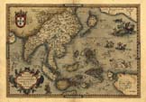
PTOLEMAIC
OVERVIEW, 1598
|
=*a
complete set of Ptolemaic maps, 1598* by Girolamo
Porro, and an overview map, to see how they fit together |
| AKBAR'S INDIA |
=*"Hindoostan, divided into Soubahs
according to the Ayin Acbaree"*, by R. Wilkinson
(1815)
=*the
Mughal Empire, c.1605** |
MUGHAL EMPIRE, 1619
|
=*William Baffin's map,
1619*, based on Sir Thomas Roe's account
|
MUGHAL EMPIRE,
5 OVERVIEWS
|
Maps of the rise and fall of the Mughal Empire
by:
=*Joppen, 1907*
=*Roolvink,
1957*
=*Majumdar, n.d.*
=*Times
Books, 2007*
and especially the DSAL zoomable Schwartzberg atlas:
=*the Mughals: an
overview*
=*Babur,
Humayun, and Sher Shah, c.1526-1555**
=*the
Mughal Empire, c.1605**
=*Jahangir,
Shah Jahan, Aurangzeb, c.1605-1707**
=*Mughal
disintegration and the rise of regional powers,
c.1707-1766** |
|
MISCELLANY, 1600s
|
=*India, Asia, and various other maps
from the 1600s* |
|
BERTIUS ATLAS
MAPS, 1600
|
=*South
Asia
and beyond, 1600*, atlas maps by Petrus Bertius |
|
'MERCATOR'
ATLAS MAPS, early 1600's, 1634
|
=*South Asia and beyond, early 1600's*,
in atlas maps by Mercator and Hondius, et al.; and an
updated later *atlas from 1634* |
| ASIA, 1630 |
=*Asia, 1630*, from a Portuguese
atlas |
THE DUTCH IN SURAT, 1629
|
=*"Logie
van Suratte"*, the Dutch factory as it looked 1629,
and other views
|
|
MUGHAL EMPIRE,
1638
|
=*the
Mughal Empire, 1638*, by Willem Blaeu (based on
Roe's journey)
|
|
ATLAS MAPS,
1652-
|
=*South
Asia
and beyond, 1652 on*, atlas maps by Nicholas
Sanson |
|
ATLAS MAPS,
1661-
|
=*South
Asia
and beyond, 1661 on* by Philip Cluver |
|
ATLAS MAPS,
1663
|
=*South
Asia and beyond, 1663*, by Pierre Duval |
|
SOUTH INDIA,
1682
|
=*South
India,
1682*, by Johan Nieuhoff |
|
MALLET, 1683-1719
|
=*Mallet's maps and views, 1683-1719, of
everything* |
|
ATLAS MAPS,
1688
|
=*South
Asia
and beyond, 1688*, by Robert Morden |
MUGHAL EMPIRE, 1700
|
=*Magni
Mogolis Imperium, 1700*, by Pieter Mortier
|
|
MISCELLANY,
earlier 1700s
|
=*India, Asia, and various other maps
from the earlier 1700s* |
VAN DER AA, 1706
|
=*Maps and routes
of travels and explorations*
|
|
ATLAS MAPS,
1721
|
=*South
Asia and beyond, 1721*, by Nicholas de Fer |
|
DE L'ISLE'S
DECCAN AND SOUTH, 1723
|
=*maps
by
Guillaume de l'Isle*, especially
=*the Deccan and the South, 1723* |
|
MOLL'S MADRAS,
1726
|
=*many
atlas maps by Herman Moll*, especially
=*India, 1715*, and above all
=*Madras, 1726* |
|
SALMON MAPS, 1729
on
|
=*India,
Asia,
maps and views, 1729-52* by Thomas Salmon |
|
SOUTH INDIA, 1733
|
=*atlas
maps
by J. B. Homann*, and *South India, 1733* |
|
ATLAS MAPS,
1740
|
=*India,
Ceylon,
Asia, etc., 1740*, atlas maps by Isaac Tirion |
S/SE ASIA by BOWEN, 1747
|
=*South and Southeast
Asia, 1747*, by Emanuel Bowen
|
|
DE VAUGONDY, 1748
on
|
=*atlas
maps,
1748 on*, by de Vaugondy; and *Asia, 1762* |
|
ASIA, 1762
|
=*Asia,
with political borders*, a large and useful
overview map by Jean Janvier, Paris |
| . |
. |
|
BELLIN MAPS
|
A group
of mid-century maps by the influential French
cartographer *Jacques-Nicolas Bellin*
(1703-1772): |
|
NORTH INDIA,
1752
|
*North
India,
1752* |
|
SOUTH INDIA,
1752
|
*South
India,
1752* |
|
WEST /
MALABAR
|
*Persian Gulf, Gujarat, Malabar Coast,
1740s* |
|
DIU, 1746
|
*"Ville
de Diu," 1746* |
| SURAT, c.1750 |
*"View of Surat," c.1750* |
|
BOMBAY, 1750
|
*"A
Plan
of Bombay," 1750* |
DABUL, 1761
|
*"View
of Dabul," 1761*
|
| RAJAPUR, c.1750 |
*"The Bay,
Town, and Forts of Andarajapour," c.1750*
|
|
GOA, 1750
|
*"Plan
of Goa," c.1750* |
CANANORE,
c.1750
|
*"Plan of
Cananore," c.1750*
|
MAHÉ, c.1764
|
*"Plan
of Mahe," c.1764*
|
CRANGANORE, c.1750
|
*"Plan of
Cranganore," c.1750*
|
|
COCHIN, c.1750
|
*"Ville
de
Cochin," c.1750* |
QUILON, c.1747
|
*Plan de la
Forteresse de Coylan, c.1750's*
|
|
EAST /
COROMANDEL
|
*Bay of Bengal; Coromandel Coast and
its colonial wars, c.1746-56* |
|
BENGAL, 1747
|
*Bengal
and
its small kingdoms, 1747* |
HUGHLY, 1721
|
*Plan
of the Dutch factory at Hughly as it was in 1721 (1752)*
|
MASULIPATAM,
1752
|
*A view
of Masulipatam, 1752*
|
| PULICAT, 1752 |
*Plan
of the Dutch fort of Geldria, at Pulicat, 1752* |
|
MADRAS, 1746
|
*"Madras
and
Fort St. George: the French victory of 1746"* |
|
PONDICHERRY,
1741
|
*"Plan of Pondicherry in 1741"* |
|
TRANQUEBAR,
1753
|
*"Carte du district de Tranquebar,"
1753; and a plan of the fort* |
|
CEYLON, 1750
|
*"Carte
de
l'isle de Ceylan," 1750* |
|
JAFFNAPATAM,
1761
|
*"Jaffenapatam,"
1761* |
TRINCOMALEE, c.
1750
|
*"Carte
de la Baye de Trinquemale," c.1750*
|
POINT DE GALLE, 1752
|
*Plan
of Point de Galle, 1752*
|
MALDIVE
ISLANDS, c.1750
|
*Map of the
Maldive Islands, c.1750*
|
|
WORLD,
mid-1700's
|
*Maps and views by Bellin, from
Prévost, mid-1700's* |
|
SEA MAPS,
c.1747
|
*Maps of the winds and seas, c.1747* |
ANCIENT ASIA
|
*Bellin's view of
Asia in antiquity, c.1760*
|